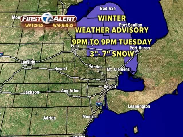

WINTER WEATHER ADVISORY FOR ST. CLAIR, LAPEER AND SANILAC COUNTIES FROM 9PM TONIGHT TO 9PM TUESDAY EVENING. SNOW ACCUMULATIONS OF 3-7 INCHES POSSIBLE.
This evening some rain/snow mixed showers will be around, especially east. The heaviest snow will come late tonight and tomorrow in the I69 area and farther north.
The next 48 hours:
This evening: Mostly cloudy with a 30% chance of mixed rain/snow showers. Temps: 35-40 / Winds: W 5-10
Tonight: Turning colder with light snow showers. Only a dusting possible in Detroit. Lows: 27-31/ Winds WNW 5-10
Tuesday: Cloudy with snow showers likely and heaviest amounts in the advisory areas. Very little around Detroit and south. Highs: 33-37/ Winds: W 10-20
Wednesday: Mostly cloudy, breezy, cold with a 40% chance for snow showers. Highs: 23-27 / Winds: NW 10-25
What does the weather look like where you live? Snap a photo and send it in, we may use it on air! Submit and view weather photos here.
CHECK THE 7-DAY FORECAST HERE.
Connect with 7 First Alert Meteorologists on Facebook and Twitter:
Facebook: Keenan Smith, Dave Rexroth, Chris Edwards, and Hally Vogel
Twitter: Keenan Smith, Dave Rexroth, Chris Edwards and Hally Vogel
