

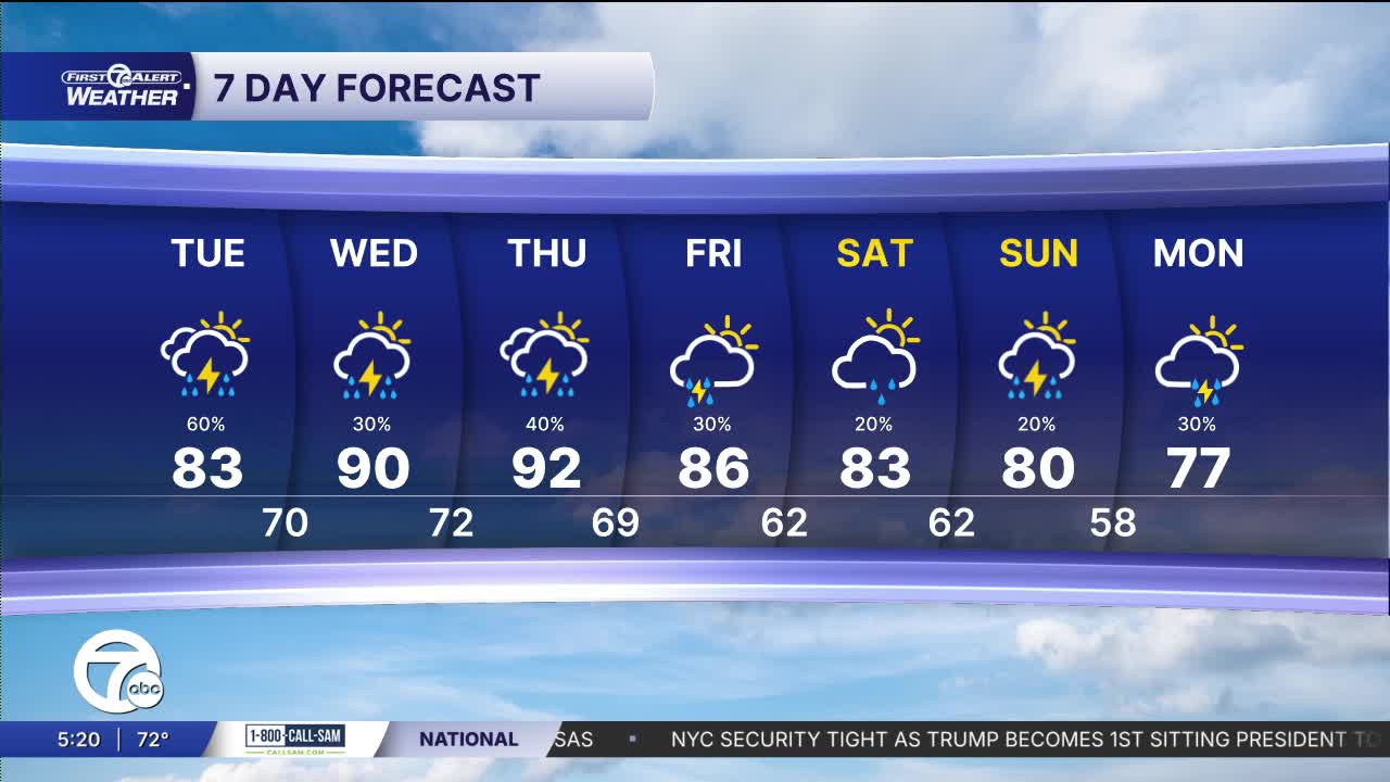


Unsettled weather continues Tuesday with scattered showers and thunderstorms likely. Heavy rainfall is possible and could lead to minor flooding. High temperatures climb into the low 80s in the afternoon with dew points near 70°.
Watch the forecast below
The active weather pattern continues Wednesday and Thursday. Highs surge into the upper 80s and low 90s. Humidity also remains high. Thunderstorms are likely both days and some storms could become strong or severe, especially late Thursday through Thursday night. While it won’t rain all the time, residents should stay weather aware, especially during the afternoon and evening hours because of those chances of stronger storms.
A cold front finally brings some relief heading into the weekend. Temperatures ease back into the mid 80s starting Friday. Another chance of storms arrives Sunday. Overall, the weekend looks more comfortable compared to the heat and humidity expected through the workweek.
Tonight: Partly to mostly cloudy with a slight storm chance. Lows near 70°. Winds: SE 5-10 mph
Tuesday: Mostly cloudy with showers and a few thunderstorms likely scattered around the area. Highs in the low 80s, but it will be much muggier. Winds: SSW 10-20 mph.
Wednesday: Mostly cloudy with a few showers and storms. A few could be strong to severe. Highs in the upper 80s, to near 90°.
Connect with 7 First Alert Meteorologists on Facebook and X:
Facebook: Dave Rexroth , Hally Vogel, Marisa Woloszyn, Mike Taylor
X: Dave Rexroth , Hally Vogel, Marisa Woloszyn, Mike Taylor
Current Conditions
- Humidity: 44%
- Dew point: 52°
- Pressure: 29.95 in
- Wind speed: 14 mph
- Wind direction: WNW
- Visibility: 10.0 mi
- Sunrise: 07:11 AM
- Sunset: 07:46 PM
