

WINTER WEATHER ADVISORY IN EFFECT FROM 5 AM TO 4 PM EST FRIDAY FOR ALL OF METRO DETROIT.
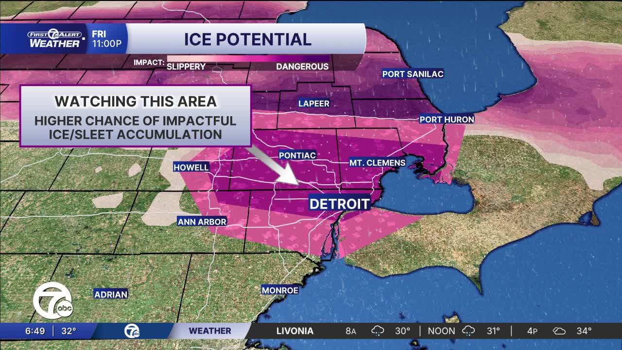
After a quiet Christmas Day, our weather pattern is shaping up to bring a notable wintry mix with a real risk of freezing rain and ice accumulation across Metro Detroit and southeast Michigan tomorrow. A quick moving storm system moving through the region will spread precipitation Friday morning (after 6 am) that starts as freezing rain, especially between the morning hours and early afternoon, because temperatures are forecast to hover right around the freezing mark. That’s a setup that favors ice forming on contact — both on roads and on elevated surfaces like bridges and power lines.
See the latest forecast in the video below
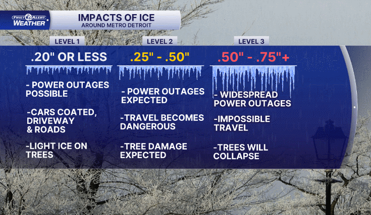
Confidence is growing Metro Detroit will see ice accumulations between 0.1″ - 0.25″ in spots, enough to create slick roads, hazardous travel conditions, and even potential power issues if ice sticks to lines and trees.
Since freezing rain bonds directly to pavement and doesn’t quickly melt or wash away like snow - untreated roads, secondary streets, sidewalks, and overpasses could become very slick.Travel Friday morning and around the midday commute looks like it could be tricky, By the afternoon and evening, as temperatures slowly creep back above freezing and leftover precipitation changes to plain rain, the worst of the ice threat should diminish, though surfaces that have already iced up will remain slippery through the early part of the weekend until crews can treat and clear them.
Bottom line: Friday looks like a classic freezing rain set up. If you must travel, plan for extra time, slow speeds and stay updated with the latest forecasts.
Tonight: Cloudy skies with lows around 30 and a wintry mix approaching. Winds: E 10-15 mph.
Friday: Freezing rain possible in the morning along with sleet and plain rain as the temps get above freezing. Winds: E 10-15 mph.
Connect with 7 First Alert Meteorologists on Facebook and X:
Facebook: Dave Rexroth , Hally Vogel, Marisa Woloszyn, Mike Taylor
X: Dave Rexroth , Hally Vogel, Marisa Woloszyn, Mike Taylor
Current Conditions
- Humidity: 37%
- Dew point: 58°
- Pressure: 29.95 in
- Wind speed: 9 mph
- Wind direction: NW
- Visibility: 10.0 mi
- Sunrise: 06:23 AM
- Sunset: 08:54 PM
