

There will be more late storms Wednesday and Wed. night. A few could be severe. Flooding becomes a bigger concern through Wed. night.
Any storms will be over by midnight leaving behind partly cloudy skies and cool temperatures. Overnight lows will settle into the lower and middle 50s across much of Metro Detroit, with a light southwest breeze around 5 to 10 mph. It will be a comfortable night once the rain exits.
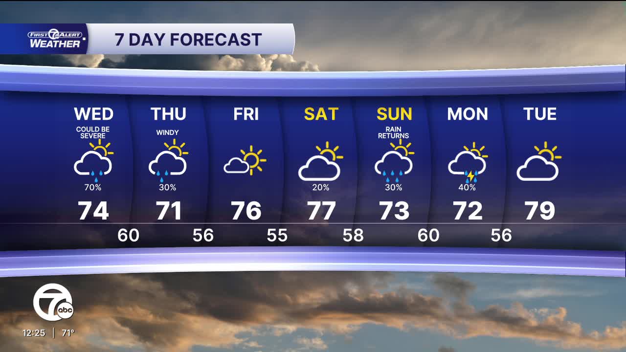
HERE IS YOUR FULL FORECAST
Wednesday starts relatively quiet with a mix of clouds and some sunshine. Temperatures will climb back into the low to mid-70s during the afternoon. Most of the day looks dry, but attention turns to a stronger system expected to approach later in the day and Wednesday night. The atmosphere will become increasingly favorable for stronger thunderstorms, especially during the evening and overnight period.
The greatest threat for stronger storms appears to be Wednesday evening through the overnight hours, mainly from around 6 PM through 3 AM. The highest risk looks to be south of I-94. Damaging wind, hail, and localized flooding appear to be the primary concerns, while a tornado threat remains lower but cannot be completely ruled out. Be sure to stay weather aware and have a way to receive alerts Wednesday night.
Some showers are possible into Thursday morning. Highs Thursday won't change much. Friday looks dry with sunshine and temperatures in the mid-70s. The weekend remains seasonably mild with highs in the upper 70s. Saturday appears to be the pick of the weekend with a mix of sun and clouds, while occasional rain chances return Sunday and Monday.
Tonight: Storms and rain move out by midnight with calmer skies after that with lows near 57. Winds SW 5-10 mph.
Wednesday: Some showers are possible late in the day. Storm chances increase after 6 PM through Wednesday night. Very heavy rain is likely leading to possible flooding. Highs in the mid 70s. Winds: SSW 10-20 mph.
Thursday: Partly sunny with a few showers possible in the morning. Highs in the low to mid 70s with winds from the WSW at 15-30 mph.
Connect with 7 First Alert Meteorologists on Facebook and X:
Facebook: Dave Rexroth , Hally Vogel, Marisa Woloszyn, Mike Taylor
X: Dave Rexroth , Hally Vogel, Marisa Woloszyn, Mike Taylor
Current Conditions
- Humidity: 79%
- Dew point: 67°
- Pressure: 29.84 in
- Wind speed: 4 mph
- Wind direction: NE
- Visibility: 10.0 mi
- Sunrise: 06:25 AM
- Sunset: 08:52 PM
