

Rain overnight is likely and some storms are possible. More rain chances Tuesday through Thursday. Cooler temperatures with highs in the 50s after Tuesday.
There is a marginal risk for severe thunderstorms in Lenawee County, with damaging wind gusts near 60 mph the threat. A higher risk for severe storms remains well to our southwest.
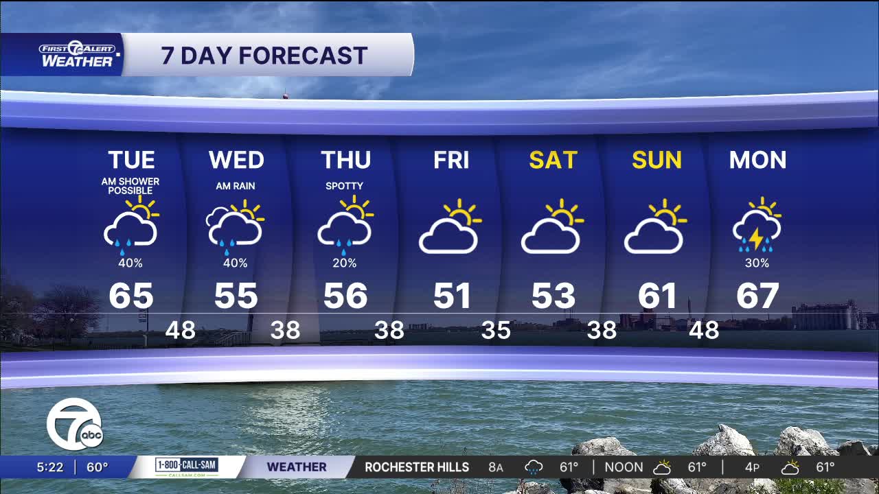
Watch the forecast below
Isolated showers continue into Tuesday morning, mainly before 10 a.m. Morning temperatures will be near 60°. Temperatures climb into the mid 60s, before dropping through the late afternoon. Skies remain mostly cloudy Tuesday.
Rain chances continue Wednesday and Thursday across Metro Detroit. A weather system slides to our southeast Wednesday, but it will be close enough to bring some rain chances, especially south of Detroit. Thursday rain will be very isolated. High temperatures will be in the low to mid 50s both days.
Drier weather returns Friday and continues into the weekend. High stay in the low to mid 50s; lows fall into the mid 30s, which brings danger to sensitive plants for frost.
Tonight: Rain is likely and storms are possible through 1 AM. A few showers could remain after that. Lows near 60°. Winds: SSE 15-30mph.
Tuesday: AM showers, then cloudy in the morning. Some sun will be possible in the afternoon. Highs in the mid to upper 60s, then breezy and cooler temps by the afternoon. Wind: W 15-30 mph.
Wednesday: Mostly cloudy with showers possible. Highs will be in the mid 50s. Winds: NE 10-20 mph.
Connect with 7 First Alert Meteorologists on Facebook and X:
Facebook: Dave Rexroth , Hally Vogel, Marisa Woloszyn, Mike Taylor
X: Dave Rexroth , Hally Vogel, Marisa Woloszyn, Mike Taylor
Current Conditions
- Humidity: 87%
- Dew point: 72°
- Pressure: 29.95 in
- Wind speed: 3 mph
- Wind direction: S
- Visibility: 10.0 mi
- Sunrise: 05:59 AM
- Sunset: 09:14 PM
