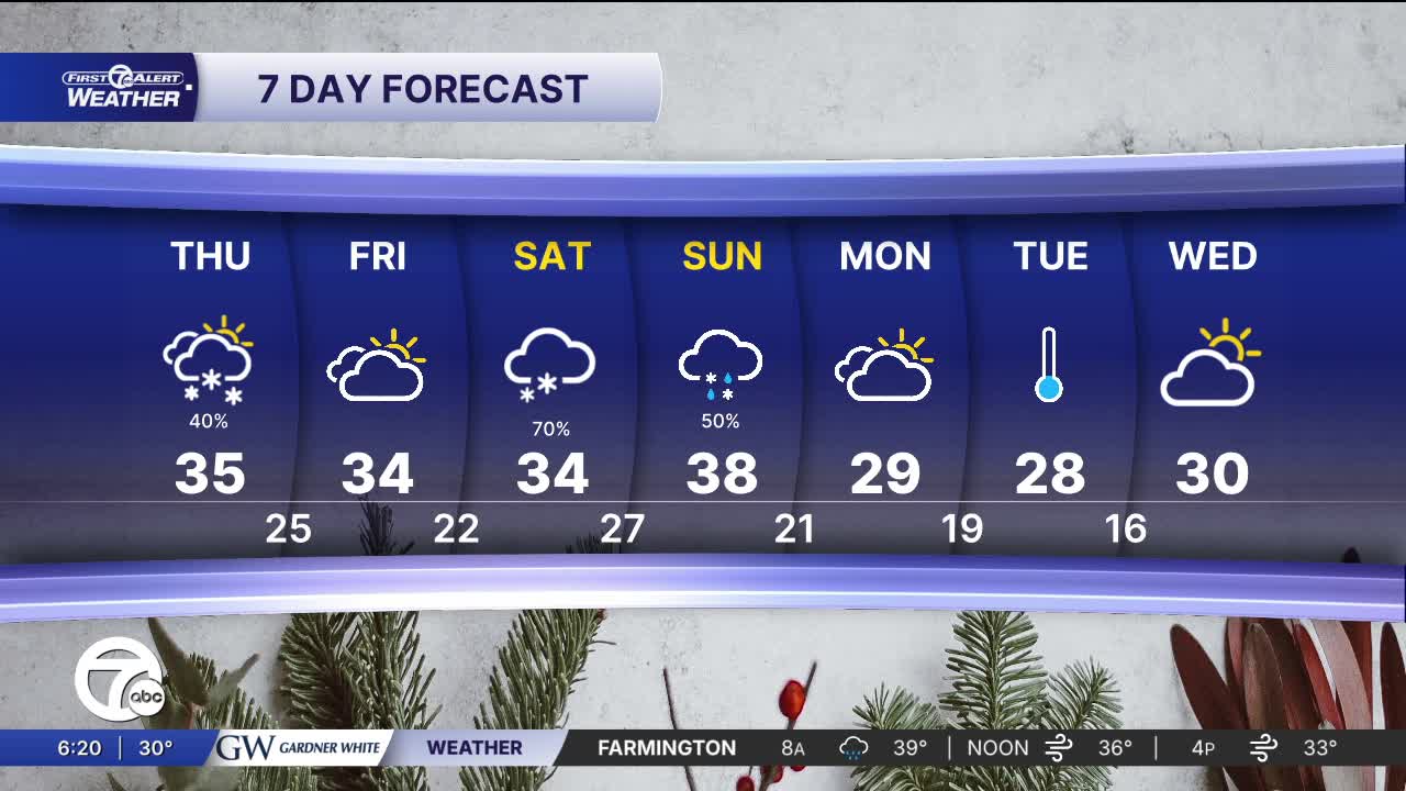


Cold winds will blow in snow showers Thanksgiving Day. Wind chills will be in the teens and 20s with up to 2" of snow in metro Detroit. North and west could get more.
See the full forecast in the video below
Overall snow accumulation through Thursday: a decent chance for at least a light dusting to 2" in some spots, which is enough to coat lawns, cars, or sidewalks, and possibly leave a thin film on roads. During the day Thursday, the steadiest snow will be in the thumb region. Friday will be better for travel. It will still be cold, but roads should be drier.
This weekend is shaping up to be our first true taste of a decent winter storm setup, with colder air locking in and a disturbance sliding across the Great Lakes that will help generate widespread snow and some mixed precipitation. Saturday starts off chilly with highs only in the low 30s and thickening clouds as the day goes on. Light snow or flurries may begin in the morning, but the better chance for steadier / heavier snow arrives Saturday afternoon into Saturday night as the main energy approaches. Roads should become slick after sunset as temperatures fall below freezing.
By Sunday, the storm’s influence becomes more noticeable: snow is likely during the morning, and depending on how warm the lower levels get, some areas may briefly mix with sleet or rain later in the day — especially closer to Detroit proper. For totals, this looks like a light to moderate event, with many areas in line for 3" – 4" of snow. Winds will be another factor, with gusts adding a bit of the bite to the cold and reducing visibility during heavier bursts of snow. While this isn’t a major winter storm, it’s enough to slow travel, coat roads, and leave the city with its first more widespread coat of snow this season. If you'll have holiday travel plans Saturday and Sunday it's definitely worth keeping an eye one.
Thanksgiving Day: Mostly cloudy, windy, and cold wind chills from 15° - 20°. A few snow showers are possible. They will be most common in the thumb. Winds: W 25-40 mph.
Friday: Mostly cloudy and cold with highs in the low to mid 30s.
Connect with 7 First Alert Meteorologists on Facebook and X:
Facebook: Dave Rexroth , Hally Vogel, Marisa Woloszyn, Mike Taylor
X: Dave Rexroth , Hally Vogel, Marisa Woloszyn, Mike Taylor
Current Conditions
- Humidity: 37%
- Dew point: 58°
- Pressure: 29.95 in
- Wind speed: 9 mph
- Wind direction: NW
- Visibility: 10.0 mi
- Sunrise: 06:23 AM
- Sunset: 08:54 PM
