

Watch the forecast below
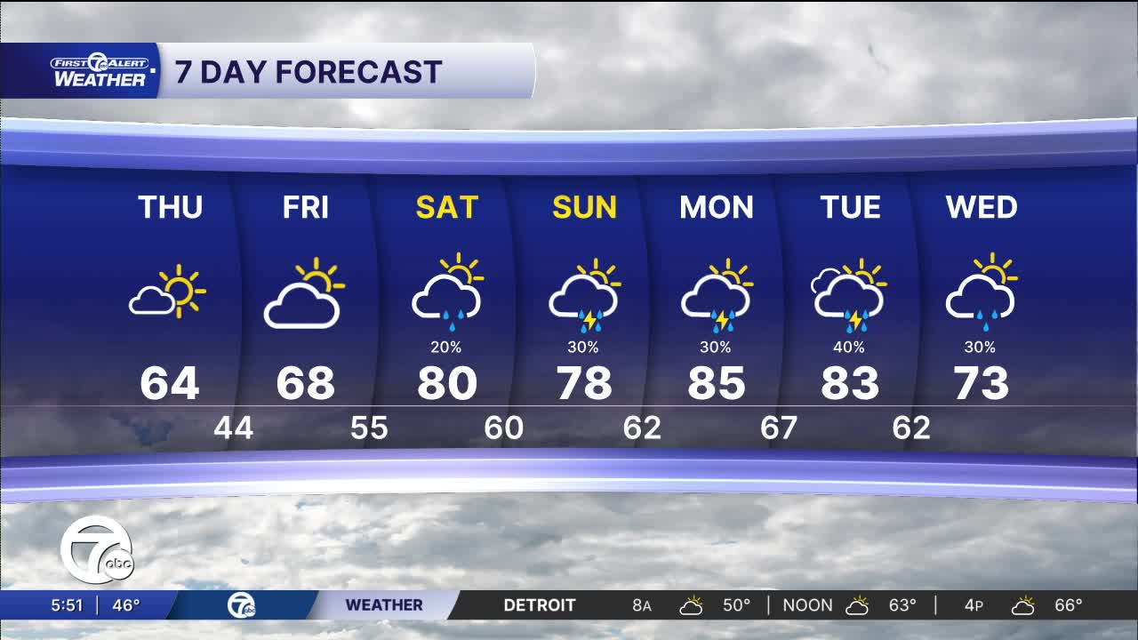
The warmest days, in the upper 70s to mid 80s, will stretch from Saturday through Tuesday. Rain and storms chances will slowly increase.
Skies gradually clear overnight as cooler air settles into Southeast Michigan. Overnight lows fall into the lower to middle 40s for most communities, with some of the traditionally cooler inland spots briefly dipping near 40 degrees by early Thursday morning. Winds remain out of the northwest around 10 to 20 mph at times, so it will still feel crisp.
Thursday brings a much more comfortable spring setup with a good batch of sunshine returning to Metro Detroit. Temperatures rebound nicely through the day, climbing from the upper 40s in the morning into the lower 60s by afternoon.
The warming trend continues into Friday with highs returning to around 70 degrees under partly sunny skies. By the weekend, temperatures surge well into the upper 70s and lower 80s as a warmer and more active weather pattern develops across the Great Lakes. While Saturday looks mainly warm with only a slight shower chance, scattered showers and thunderstorms become more possible Sunday into early next week. Monday currently appears to be the warmest day with highs potentially reaching the mid 80s before additional rain chances arrive Tuesday.
Tonight: Clouds break late. Lows of 39° to 43°. Winds: NW 10-15 mph.
Thursday: Partly to mostly sunny with highs in the low to mid 60s. Winds N 10-20 mph.
Friday: Partly sunny with highs in the upper 60s. Winds S 10-15 mph.
Connect with 7 First Alert Meteorologists on Facebook and X:
Facebook: Dave Rexroth , Hally Vogel, Marisa Woloszyn, Mike Taylor
X: Dave Rexroth , Hally Vogel, Marisa Woloszyn, Mike Taylor
Current Conditions
- Humidity: 87%
- Dew point: 72°
- Pressure: 29.95 in
- Wind speed: 3 mph
- Wind direction: S
- Visibility: 10.0 mi
- Sunrise: 05:59 AM
- Sunset: 09:14 PM
