

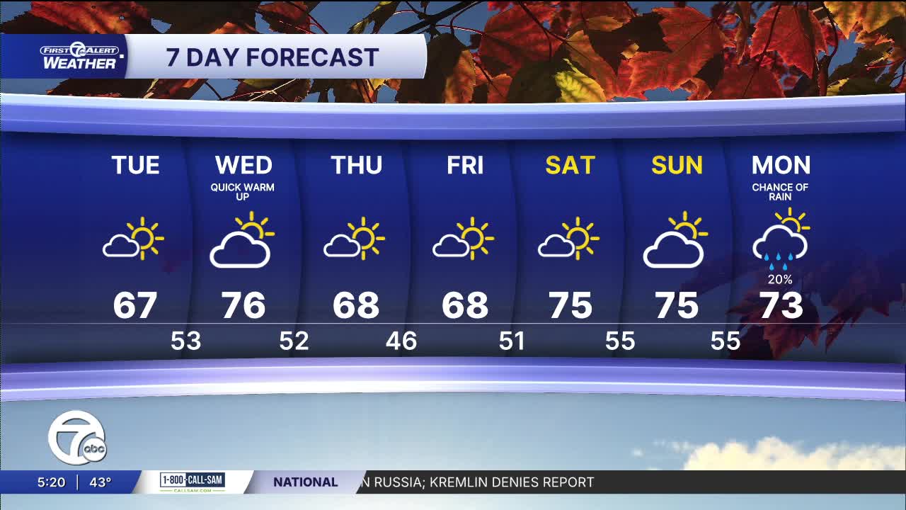


Tuesday starts chilly across Metro Detroit, with temperatures in the low to mid-40s for the morning commute. Grab a jacket before heading to work or school! Plenty of sunshine will help temperatures climb into the upper 50s by late morning and the mid-60s through the afternoon.
Expect a pleasant fall afternoon, with Detroit reaching a high near 67 degrees—right around normal for early October. Highs across Southeast Michigan will range from the mid-60s near Port Huron to around 70 in Adrian. South-southeast winds will stay light at 5–10 mph.
Tonight will be mostly clear and noticeably milder than this morning. Temperatures will settle into the low to mid-50s, including a low near 53 degrees in Detroit. South-southwest winds will continue at 5–10 mph.
Wednesday brings the warmest temperatures of the week, with plenty of sunshine and a high near 76 degrees in Detroit. Morning temperatures in the mid-50s will rise into the upper 60s by noon and the mid-70s during the afternoon. Some communities south of Detroit could reach 78 degrees, with west-southwest winds at 10–15 mph.
Temperatures ease back into the upper 60s Thursday and Friday under partly sunny skies. The warmth returns for the weekend, with highs near 75 degrees both Saturday and Sunday and a mix of sun and clouds. Most of the extended forecast stays dry, with a small, 20% chance of rain Monday as highs reach the low 70s.
Today: Mostly sunny with highs in the mid 60s and 65° in Detroit. Winds: SSW 5-10 mph.
Tonight: Mostly clear with lows back in the 50s°. Winds: SSW 5-10 mph.
Wednesday: Partly sunny with highs in the low 70s and 76° in Detroit. Winds: WSW 10-20 mph.
Connect with 7 First Alert Meteorologists on Facebook and X:
Facebook: Dave Rexroth , Hally Vogel, Marisa Woloszyn, Mike Taylor
X: Dave Rexroth , Hally Vogel, Marisa Woloszyn, Mike Taylor
Current Conditions
- Humidity: 95%
- Dew point: 39°
- Pressure: 30.21 in
- Wind speed: 2 mph
- Wind direction: N
- Visibility: 10.0 mi
- Sunrise: 07:36 AM
- Sunset: 07:05 PM
