



Severe storms are moving through metro Detroit. Check out the latest alerts here.
Flood Warnings have been issued for Wayne, Macomb, and Oakland counties until 5:30 AM by the National Weather Service and are set to expire early Thursday morning.
We’re also watching the potential for strong to severe thunderstorms into the overnight hours. The greatest concern appears to be through 10 PM. Damaging wind gusts up to around 70 mph and large hail approaching 1.75 inches are the main threats. A tornado is also possible, and localized flooding could develop underneath heavier storms.
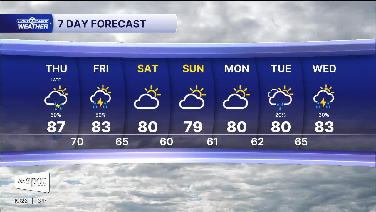
Thunderstorms may continue into tonight before gradually winding down. It will remain warm and muggy, with overnight lows generally in the upper 60s to lower 70s. Detroit falls to around 73°, while many suburbs settle closer to 68°–70°.
Thursday won’t be quite as hot, but another round of thunderstorms will be possible, including the potential for some severe storms. Highs range from around 80° in the Thumb to the middle 80s south of Detroit, with Detroit near 83°.
By Friday, temperatures settle closer to 80°, but showers and thunderstorms remain possible and some could be intense. The pattern finally quiets down for the holiday weekend. Drier air returns Saturday, with highs around 79°, followed by partly cloudy skies and temperatures near 80° Sunday and Labor Day. Another chance for showers returns Tuesday.
Tonight: Storm chances continue at times. Mostly cloudy with lows in the low to mid 70s. Winds: SW 5-10 mph.
Thursday: Partly sunny with heavy storms possible. Highs in the upper 80s.
Connect with 7 First Alert Meteorologists on Facebook and X:
Facebook: Dave Rexroth , Hally Vogel, Marisa Woloszyn, Mike Taylor
X: Dave Rexroth , Hally Vogel, Marisa Woloszyn, Mike Taylor
Current Conditions
- Humidity: 40%
- Dew point: 42°
- Pressure: 30.35 in
- Wind speed: 4 mph
- Wind direction: E
- Visibility: 10.0 mi
- Sunrise: 07:52 AM
- Sunset: 06:42 PM
