

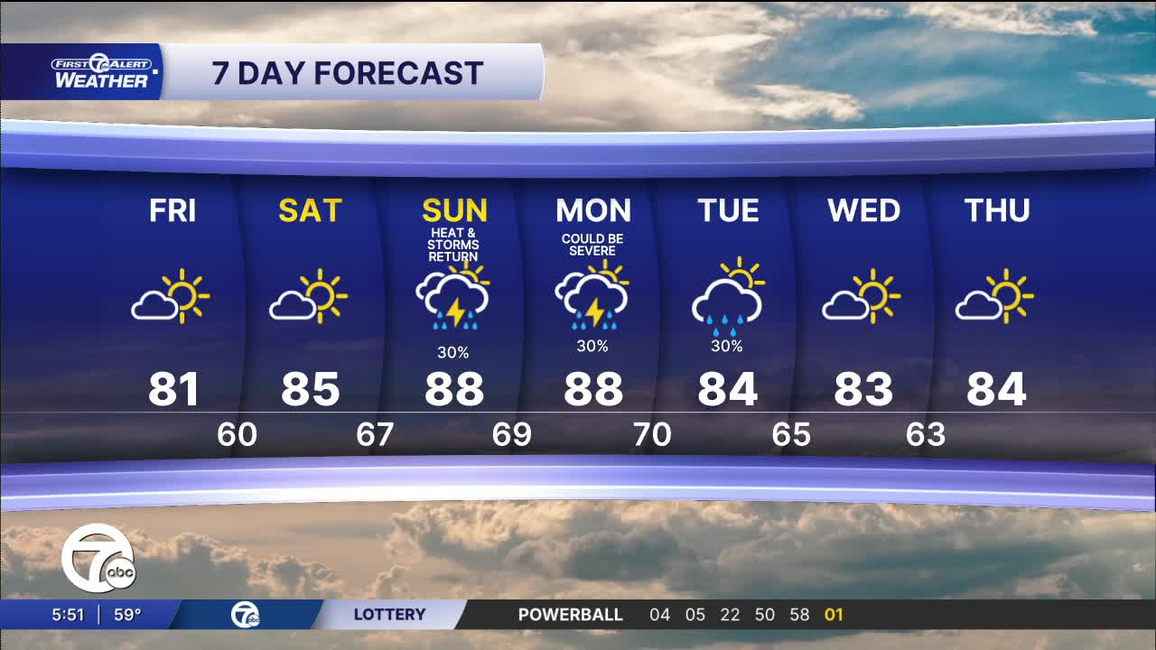


A comfortable start this morning gives way to a warm summer afternoon. Expect a mix of sun and clouds through the day with highs reaching around 80 to 81 degrees across much of Metro Detroit. Winds stay light out of the east-southeast at 5 to 10 mph, making for a pleasant day to get outside. Most neighborhoods remain dry from sunrise through sunset.
See the full forecast in the video below
Skies stay partly cloudy overnight with comfortable humidity and light south-southwest winds around 5 to 10 mph. Overnight lows fall into the upper 50s across the northern suburbs and near 60 in Detroit, making for another mild July night.
The warming trend continues as highs climb into the lower to middle 80s, with Detroit topping out near 85 degrees. Expect a mix of sunshine and a few passing clouds with light west winds. It stays dry through the day, making Saturday one of the better outdoor days of the weekend.
Summer heat begins to build by Sunday with highs pushing the upper 80s. Humidity also increases, and a few afternoon or evening thunderstorms become possible. Sunday's storms could be intense and persistent leading to flooding in some areas. Storm chances continue into Monday, when a few stronger storms could develop. These will be watched over the weekend and they could become severe. By Tuesday, scattered showers and storms linger as temperatures ease back into the mid-80s. Drier weather returns for Wednesday and Thursday with a mix of sun and clouds and highs in the lower to middle 80s.
Today: Mostly sunny and warmer. Highs in the upper 70s. Winds: NNW 5 mph.
Tonight: Mostly clear with lows in the mid to upper 50s. Winds: SW 5-10 mph
Saturday: Partly cloudy skies with temps in the mid 80s. Winds: SW 5-10 mph.
Sunday: Storms are possible as the summer heat returns. Highs will be near 90.
Connect with 7 First Alert Meteorologists on Facebook and X:
Facebook: Dave Rexroth , Hally Vogel, Marisa Woloszyn, Mike Taylor
X: Dave Rexroth , Hally Vogel, Marisa Woloszyn, Mike Taylor
Current Conditions
- Humidity: 70%
- Dew point: 54°
- Pressure: 30.17 in
- Wind speed: 2 mph
- Wind direction: NNE
- Visibility: 10.0 mi
- Sunrise: 06:17 AM
- Sunset: 09:01 PM
