



A severe thunderstorm watch is in effect until 5 a.m. for Sanilac, Lapeer and St. Clair counties.
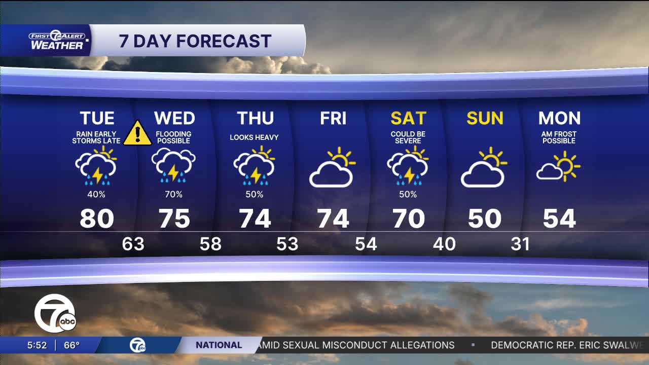
Some storms are possible overnight and into early Tuesday. There is a slight risk of strong winds or large hail. Storms are more likely to be severe Tuesday night into Wednesday.
Watch the forecast below
Warmer temperatures continue with highs staying in the mid to upper 70s and lows in the low to mid 60s through the week. A few spots could hit 80° again Tuesday.
There are multiple rounds of storms, which could be strong to severe, so please keep an eye on the forecast this week and know where to go to seek shelter if severe weather moves in. Here's a breakdown of severe storm possibilities over the next few days:
Tonight: Until 5 a.m.
A few strong to severe storms are possible until 5 a.m. These storms will move from the southwest toward the northeast across southeast Michigan. The storms have the potential for 1" hail and 60+ mph wind gusts.
Tuesday night: 10 p.m. to 6 a.m.
A line of strong thunderstorms will move in from the northwest possibly starting as early as late evening. The strongest storms look to be after midnight. All severe weather will be possible, 1" diameter hail, 60+ mph wind gusts, isolated tornadoes, and flooding.
Wednesday: 2 p.m. to 2 a.m.
Scattered thunderstorms will move in during the afternoon. 1" diameter hail, 60+ mph wind gusts, and an isolated tornado is possible.
Tonight: Some storms are possible overnight. If there is trouble it will be about strong winds or large hail. Otherwise, it will be partly to mostly cloudy with lows in the low to mid 60s. Winds: SSW 10-20 mph.
Tuesday: Rain is possible early with a rumble of thunder, then it will be partly sunny for much of the day. Highs in the upper 70s, near 80° in Detroit. Winds: SW 15-25 mph.
Strong to severe storms are possible late Tuesday evening through Tuesday night.
Wednesday: More storms are likely and a few could be severe. Steady rain will increase the flood chance. Highs in the low to mid 70s. Winds: SW 10-20 mph.
Connect with 7 First Alert Meteorologists on Facebook and X:
Facebook: Dave Rexroth , Hally Vogel, Marisa Woloszyn, Mike Taylor
X: Dave Rexroth , Hally Vogel, Marisa Woloszyn, Mike Taylor
Current Conditions
- Humidity: 49%
- Dew point: 59°
- Pressure: 29.94 in
- Wind speed: 8 mph
- Wind direction: NE
- Visibility: 10.0 mi
- Sunrise: 07:02 AM
- Sunset: 08:00 PM
