

A flood watch is in effect until 2 p.m. Wednesday for areas south of I-69. Very heavy rain is expected overnight and Wednesday.
A more organized live of storms will move through overnight moving west to east around 40 mph from 2AM to 5AM. Strong to severe thunderstorms will bring chances for damaging wind gusts near 60 mph, hail 1" in diameter (near 2" diameter possible west of US-23), tornadoes, and flooding.
Plan now for possible severe storms. Have ways to receive weather alerts, even when sleeping. Know where to go to seek shelter: think lowest level of your home and in the most interior room.
Watch the forecast below
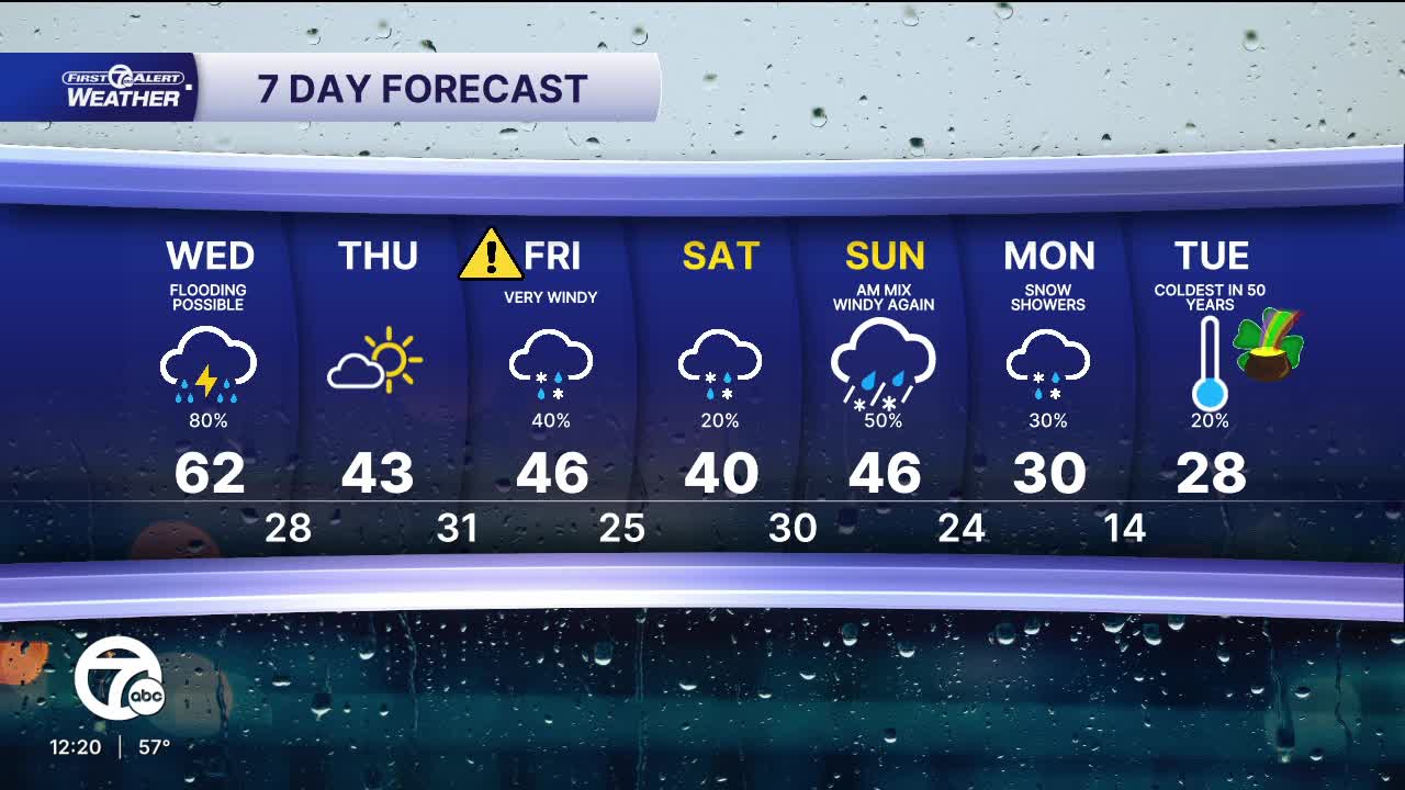
Storms will continue into Wednesday morning and some could be strong. Heavy rainfall is also expected during this time, with flooding possible. Many areas could easily get 1" of rain. Some areas could get to 2". Never drive through flood waters. Temperatures drop throughout the day with afternoon temperatures into the 40s before falling into the 20s Wednesday night.
Cooler air stays in place for the end of the week with highs in the 40s and lows in the 20s and 30s. A rain/snow mix is likely Friday.
Tonight: Strong to severe storms likely with damaging wind, flooding rain, large hail, and tornadoes all possible. Lows in the low to mid 40s. Winds: SSW 10-15 mph.
Wednesday: Storms early, a few could be strong to severe. Heavy rain at times. Highs in the mid to upper 50s around midday and then temperatures will drop. Winds will switch from SW to NW in the afternoon at 15-25 mph.
Thursday: A break from storms with sunshine and highs in the upper 30s and low 40s with 42° in Detroit. Winds: WNW 10-15 mph.
Connect with 7 First Alert Meteorologists on Facebook and X:
Facebook: Dave Rexroth , Hally Vogel, Marisa Woloszyn, Mike Taylor
X: Dave Rexroth , Hally Vogel, Marisa Woloszyn, Mike Taylor
Current Conditions
- Humidity: 41%
- Dew point: 59°
- Pressure: 29.97 in
- Wind speed: 10 mph
- Wind direction: NNW
- Visibility: 10.0 mi
- Sunrise: 06:23 AM
- Sunset: 08:54 PM
