

Heading into tonight, precipitation amounts look light and isolated, but you may notice some isolated flurries or a bit of wintry mix late this evening or overnight. Temperatures will hover around the freezing mark.
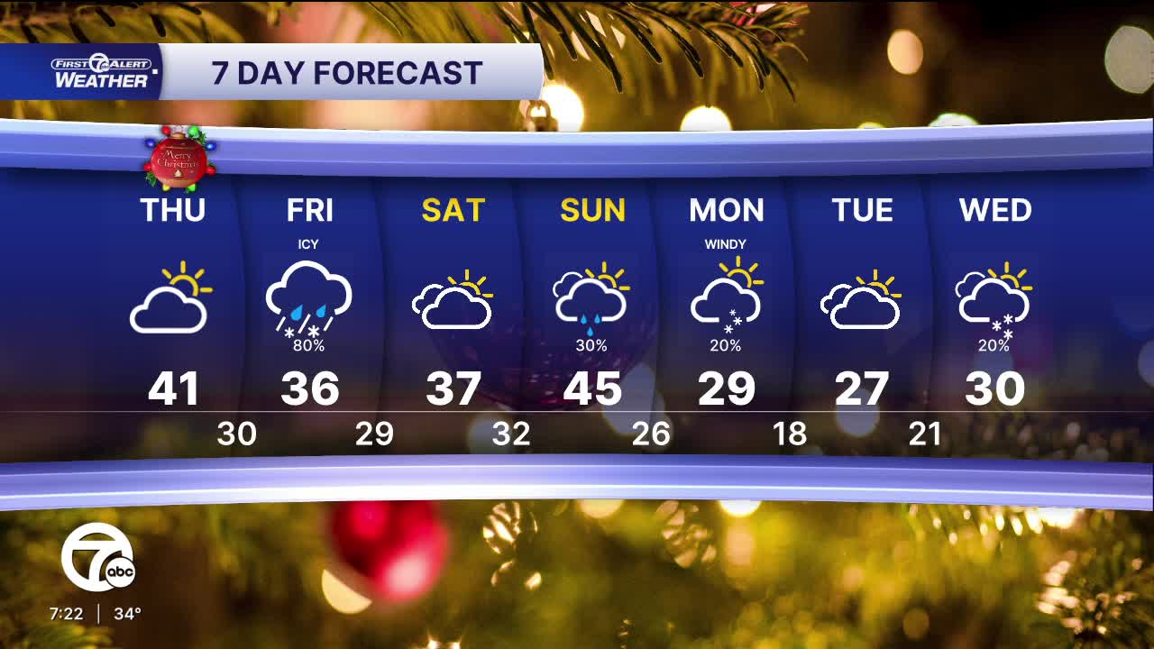
Christmas Day will feel mild again, especially compared to what you might imagine for a snowy holiday. Temperatures are expected to climb into the upper 30s to low 40s - a bit warmer than the seasonal averages with mostly cloudy skies dominating much of the day. While it won’t be a white Christmas with significant snow falling or accumulating, the chance of light rain or drizzle at times can’t be ruled out, especially in the morning when temperatures hover around the freezing mark. That means some roads could be wet or icy in spots.
A Potential Ice Storm
Looking ahead to Friday in the Detroit area, the next storm system will bring a significant wintry mix and ice potential, that could make travel tricky in the morning and around midday. A surge of moist air riding over cold surface temperatures will set the stage for freezing rain and a wintry mix Friday morning into the early afternoon. Rain falling onto near freezing roads will likely freeze on contact, a classic recipe for slick roads and ice on power lines. There's a high chance of precipitation starting as snow or freezing rain from 6AM - 10 AM, then transitioning to mainly freezing rain & rain for much of the day as temperatures hover around the low to mid 30s.

That means ice accumulations around 0.1–0.2 inch are possible with even higher amounts in some spots if surface temperatures stay stubbornly cold, which can happen with systems like this.

In short: wet, freezing precipitation Friday morning → slick travel → gradual improvement later in the day — a typical setup when warm, moist air overrides cold ground temps in late December. Stay up to date on the latest and be prepared in case power outages impact your area.
Tonight: Some drizzle possible with temps hovering around freezing. Beware of slick roads in spots. Winds: Light
Christmas Day: Another mild holiday with highs in the 40s. Mostly cloudy skies will linger with an incoming storm for Friday morning. Winds: NNE 10-15 mph.
Connect with 7 First Alert Meteorologists on Facebook and X:
Facebook: Dave Rexroth , Hally Vogel, Marisa Woloszyn, Mike Taylor
X: Dave Rexroth , Hally Vogel, Marisa Woloszyn, Mike Taylor
Current Conditions
- Humidity: 37%
- Dew point: 58°
- Pressure: 29.95 in
- Wind speed: 9 mph
- Wind direction: NW
- Visibility: 10.0 mi
- Sunrise: 06:23 AM
- Sunset: 08:54 PM
