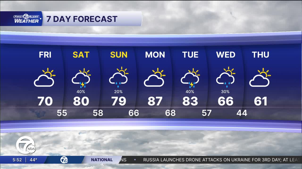


Friday starts cool with temperatures near 50 degrees in the morning before warming nicely into the middle and upper 60s during the afternoon. Clouds increase through the day with a mostly cloudy sky developing by afternoon, but most of Metro Detroit should stay dry. It’ll be another mild spring day overall with a slightly more humid feel beginning to creep in late.
Watch the forecast below
The pattern turns much more active beginning Saturday and lasting into at least Tuesday. Temperatures surge into the upper 70s and 80s with increasing humidity, creating a setup supportive of multiple rounds of showers and thunderstorms. While not every hour will be rainy, there will be periodic storm chances each day. Some storms could become strong to severe at times, especially Monday when temperatures may push into the middle 80s. Heavy rainfall may also become a concern by Tuesday as this active pattern lingers across the Great Lakes.
The severe weather risk is expected to increase across parts of the Midwest and Great Lakes as warmer, more humid air pushes northward this weekend into early next week. Right now, the highest concentration of organized severe weather appears west of Detroit initially, but Southeast Michigan remains in an active corridor where stronger storms could develop or move through at times from Saturday through Tuesday. It’s a pattern worth monitoring closely as timing and storm intensity details become clearer over the next couple of days.
Tonight: Mostly clear with lows near 44. Winds: WSW 10-15 mph.
Friday: Partly sunny with highs in the upper 60s. Winds S 10-15 mph.
Connect with 7 First Alert Meteorologists on Facebook and X:
Facebook: Dave Rexroth , Hally Vogel, Marisa Woloszyn, Mike Taylor
X: Dave Rexroth , Hally Vogel, Marisa Woloszyn, Mike Taylor
Current Conditions
- Humidity: 87%
- Dew point: 72°
- Pressure: 29.95 in
- Wind speed: 3 mph
- Wind direction: S
- Visibility: 10.0 mi
- Sunrise: 05:59 AM
- Sunset: 09:14 PM
