



Planning your day? Check out Day Planner Plus with Mike Taylor
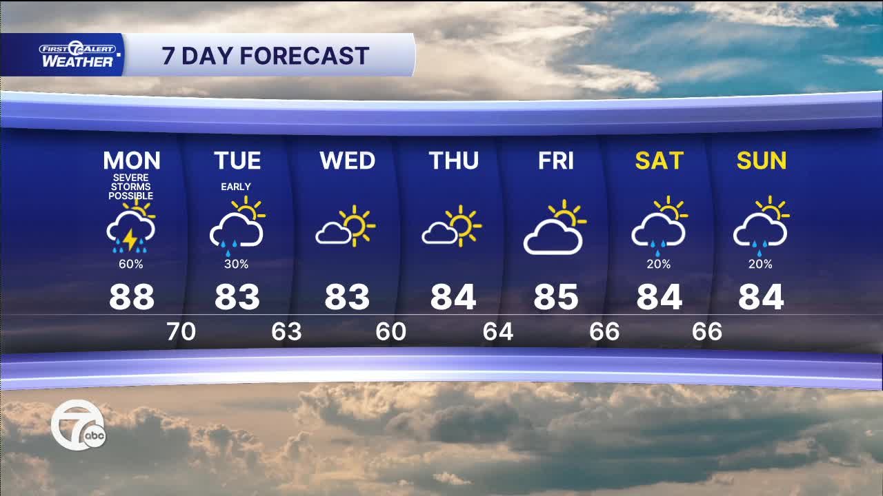
A warm and increasingly humid Monday is ahead, with afternoon highs climbing into the middle and upper 80s across Southeast Michigan. Expect a mix of clouds and sunshine through the first half of the day before thunderstorms develop later this afternoon and evening. Some of those storms could become strong to severe, with damaging wind gusts posing the primary threat. While a brief tornado or some hail can’t be ruled out, those threats remain lower. Localized heavy rainfall may also lead to isolated flooding in poor drainage areas. Winds will be out of the west-southwest at 5 to 10 mph.
Watch the forecast below
Thunderstorms will gradually move out during the evening, with quieter weather returning overnight. Skies will remain partly to mostly cloudy, and it will stay mild with overnight lows settling into the mid to upper 60s, near 70° in downtown Detroit. Winds become light and calm overnight.
Tuesday starts with plenty of clouds, but conditions improve through the afternoon as skies become partly cloudy. It’ll be noticeably less humid and comfortable compared to Monday, with afternoon temperatures topping out in the lower 80s. Most of the day stays dry, although an isolated shower can’t be completely ruled out early.
After today’s storm chance, the weather turns much quieter for the middle of the week. Tuesday features a slight chance of an early shower before drying out. Wednesday through Friday bring a pleasant stretch with a mix of sun and clouds, seasonable temperatures in the low to mid-80s, and comfortable humidity. Another small chance for a few showers or storms returns next weekend, but at this point it doesn’t look like a washout, with highs remaining in the mid-80s.
Today: Partly sunny. Strong to severe storms possible late. Highs in the mid to upper 80s. Winds: SW 5-10 mph.
Tonight: Partly cloudy with storms moving out. Lows in the upper 60s, near 70°. Winds: Calm.
Tuesday: A few showers early, then partly sunny. Highs in the low 80s. Winds: N 10-20 mph.
Connect with 7 First Alert Meteorologists on Facebook and X:
Facebook: Dave Rexroth , Hally Vogel, Marisa Woloszyn, Mike Taylor
X: Dave Rexroth , Hally Vogel, Marisa Woloszyn, Mike Taylor
Current Conditions
- Humidity: 81%
- Dew point: 70°
- Pressure: 29.82 in
- Wind speed: 8 mph
- Wind direction: SW
- Visibility: 9.0 mi
- Sunrise: 06:20 AM
- Sunset: 08:58 PM
