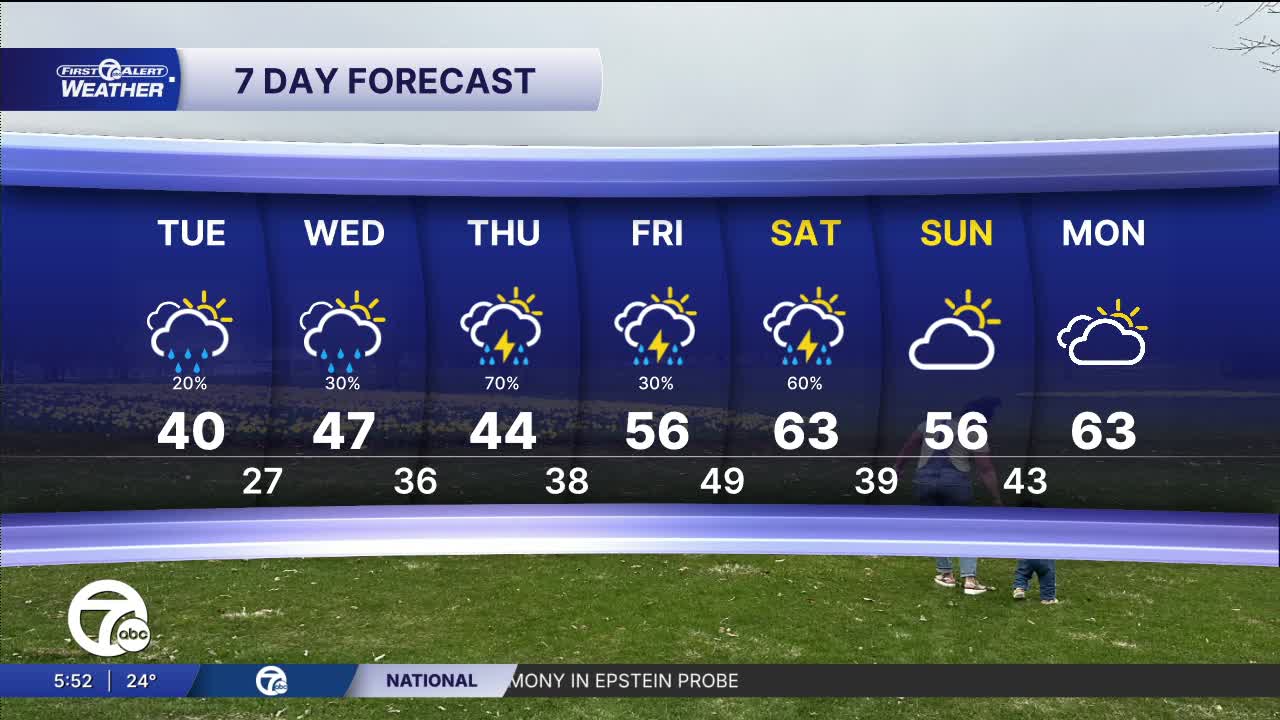


(WXYZ) — Temperatures climb every day with more rain showers through the rest of the week. The wettest days should be Thursday and Saturday. Thunder is possible from midweek on as well.
We start Tuesday with a very slight chance of spots of freezing drizzle or light freezing rain. The most likely areas will be around and south of I-94. Temperatures start in the low 20s. By the afternoon our temperatures climb into the low 40s with a slight chance for rain across all of southeast Michigan.
Two more storm systems are on the way this week, one Wednesday night and into Thursday and the other Friday night and into Saturday. These two storms will bring rain across the area with a chance for thunderstorms Friday. Temperatures climb with highs in the 50s starting Thursday and in the 60s Saturday.
Check out the forecast in the video player below:
Tonight: Partly cloudy and then more clouds late. A very slight chance of freezing drizzle or light freezing rain mostly south and toward the morning. Lows in the low 20s. Winds: ENE 5 mph.
Tuesday: A very slight chance for freezing air early, then a chance for showers. Highs in the low 40s. Winds: E 5 mph.
Wednesday: Mostly cloudy with a rain shower chance. There is a slight chance of thunder late in the day as well. Highs in the mid 40s. Winds: E 5 mph.
Connect with 7 First Alert Meteorologists on Facebook and X:
Facebook: Dave Rexroth , Hally Vogel, Marisa Woloszyn, Mike Taylor
X: Dave Rexroth , Hally Vogel, Marisa Woloszyn, Mike Taylor
Current Conditions
- Humidity: 41%
- Dew point: 59°
- Pressure: 29.97 in
- Wind speed: 10 mph
- Wind direction: NNW
- Visibility: 10.0 mi
- Sunrise: 06:23 AM
- Sunset: 08:54 PM
