

A Wind Advisory has been issued for Lapeer, Lenawee, Livingston, Macomb, Monroe, Oakland, Washtenaw, and Wayne counties from 10:00 a.m. to 9:00 p.m. on Friday.
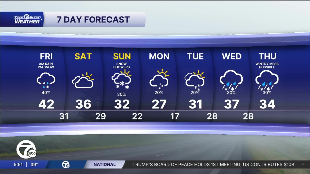
(WXYZ) — More rain and even snow remain in the forecast. Moisture increases late with rain likely redeveloping late tonight and continuing into early Friday. That means a damp start to Friday across the area with foggy conditions and rain during the morning commute, but temperatures briefly stay in the low 40s. As the system pulls away, winds shift and cooler air filters in, allowing readings to gradually fall back into the 30s through the afternoon and evening with lingering clouds as winter makes a comeback. There is a chance for light snow in the afternoon, but little to no accumulation. There will also be strong winds, with gusts up to 45mph and sustained winds between 15-25mph.
Watch the forecast
A return to more typical late-February weather this weekend gets started on Saturday with mostly cloudy skies and highs only in the mid 30s. After Friday’s rain and mild air exit, cooler air settles in and temperatures fall off quickly into the low 20s Saturday night with a quiet but colder feel heading into Sunday. Therefore, a chilly end to the weekend with cloudy skies and highs near the low 30s, Sunday. A weak system passing through the Great Lakes may bring a few periods of light snow or flurries, especially later in the day, but any accumulation looks minor at this time.
Tonight: Another round of rain and foggy conditions continue tonight with lows around 40°. Winds: ESE 5-10 mph.
Friday: Rain likely early in the morning leading to a soggy, mild & breezy start to the day. Eventually, temps will fall with wind chills in the 20s by the afternoon. Snow showers will be possible as well, as left over rain changes to snow. Highs will start off in the mid 40s before dropping into the 30s by midday. Winds: SW 20-30 mph.
Connect with 7 First Alert Meteorologists on Facebook and X:
Facebook: Dave Rexroth , Hally Vogel, Marisa Woloszyn, Mike Taylor
X: Dave Rexroth , Hally Vogel, Marisa Woloszyn, Mike Taylor
Current Conditions
- Humidity: 39%
- Dew point: 59°
- Pressure: 29.96 in
- Wind speed: 11 mph
- Wind direction: NNW
- Visibility: 10.0 mi
- Sunrise: 06:23 AM
- Sunset: 08:54 PM
