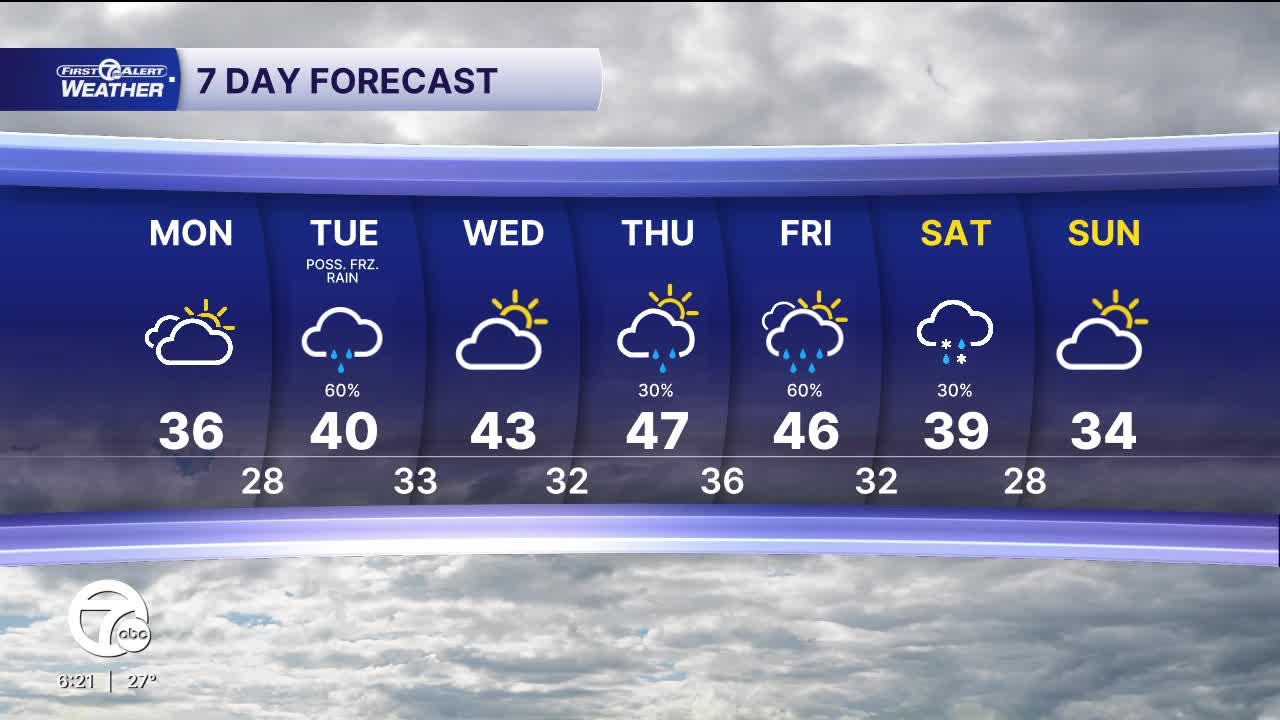


Snow showers return after midnight and continue into early Monday morning. Accumulation will be <1" for most, but communities north of I-69 will see 1-2" of new snow. Communities closer to the tip of the thumb will get close to 3".
Snow will end before sunrise Monday, but slippery conditions are likely on any untreated surface. Most of Monday will be mostly cloudy with highs in the mid 30s.
There are two storms to watch this week, one on Tuesday and one Thursday night through Saturday. Tuesday's storm will mainly bring rain across Southeast Michigan, but there is the chance for some freezing rain as showers arrive mid-morning. Be prepared for slippery travel during the day, before temperatures warm and precipitation switches to rain for the afternoon. As temperatures drop Tuesday night, precipitation will switch to snow as colder air moves in behind the storm. Little to no accumulation is expected.
The next storm moves in Thursday night, bringing rain across Southeast Michigan and snow if you're traveling Up North. Keep an eye on this system if traveling this upcoming weekend.
Check out the forecast:
Tonight: Light snow after midnight. Accumulations of a less than an inch expected for most of Metro Detroit with totals of 1"-2" possible north of I-69. Low in the mid 20s. Winds: SSE 5-10 mph.
Monday: Mostly cloudy. Highs in the mid 30s. Winds: SW 5-10 mph.
Tuesday: Rain showers, with a chance for some freezing rain. Highs near 40°.
Connect with 7 First Alert Meteorologists on Facebook and X:
Facebook: Dave Rexroth , Hally Vogel, Marisa Woloszyn, Mike Taylor
X: Dave Rexroth , Hally Vogel, Marisa Woloszyn, Mike Taylor
Current Conditions
- Humidity: 37%
- Dew point: 58°
- Pressure: 29.95 in
- Wind speed: 10 mph
- Wind direction: NW
- Visibility: 10.0 mi
- Sunrise: 06:23 AM
- Sunset: 08:54 PM
