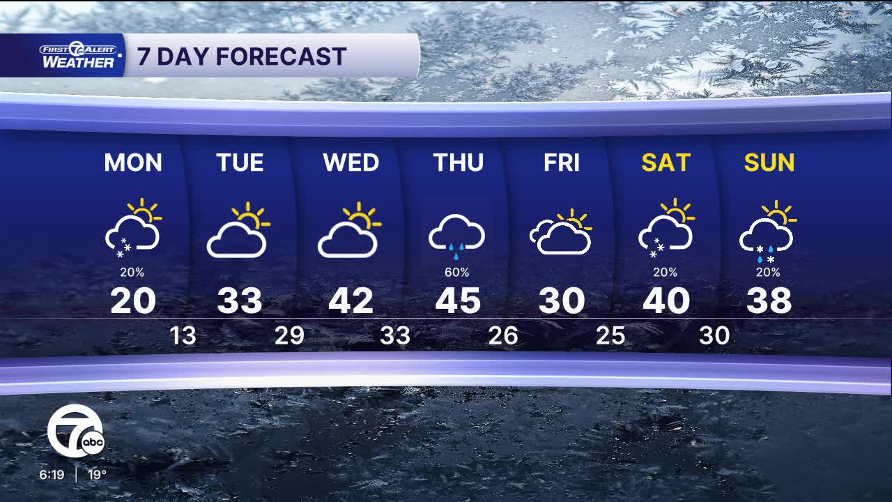


Cold weather continues into the workweek. Temperatures will start near 10° Monday morning and climb to near 20° by the afternoon. Winds will be out of the southwest 15-20 mph, with gusts near 30 mph, keeping wind chills in the single digits. A clipper system will pass to our north early Monday, with some light snow likely north of I-96. Accumulation will be less than 1/2", but there could be some slick spots. The rest of the day will be partly sunny.
Quiet and more seasonable weather returns Tuesday. Skies will be partly sunny with highs in the low to mid 30s. Partly sunny skies continue Wednesday, with highs in the low 40s.
Our warmest day will be Thursday this week, but it will also be our rainiest. Highs peak in the mid 40s Thursday. Rain showers will move in mid-morning and continue for most of the day. Rain will switch to light snow Thursday night and into Friday morning.
Tonight: Mostly cloudy. Lows near 10°. Wind: W 5-10 mph.
Monday: Light snow early, mainly north of I-96. Partly sunny. Highs in the upper teens. Winds: SW 15-20 G30 mph
Tuesday: Partly sunny. Highs in the low to mid 30s. Winds: SW 10-20 mph.
Connect with 7 First Alert Meteorologists on Facebook and X:
Facebook: Dave Rexroth , Hally Vogel, Marisa Woloszyn, Mike Taylor
X: Dave Rexroth , Hally Vogel, Marisa Woloszyn, Mike Taylor
Current Conditions
- Humidity: 37%
- Dew point: 58°
- Pressure: 29.95 in
- Wind speed: 9 mph
- Wind direction: NW
- Visibility: 10.0 mi
- Sunrise: 06:23 AM
- Sunset: 08:54 PM
