

Watch the full forecast
Some afternoon scattered snow showers are impacting visibility during the evening commute in isolated spots, as snow chances diminish into the late evening. Any accumulation is expected to be minor, only a dusting to a quarter of an inch.
Despite more sunshine, it still felt bitterly cold today.Tonight turns mostly cloudy with temperatures dropping back toward around 0°, and wind chills staying well below zero again as clouds diminish throughout the night.
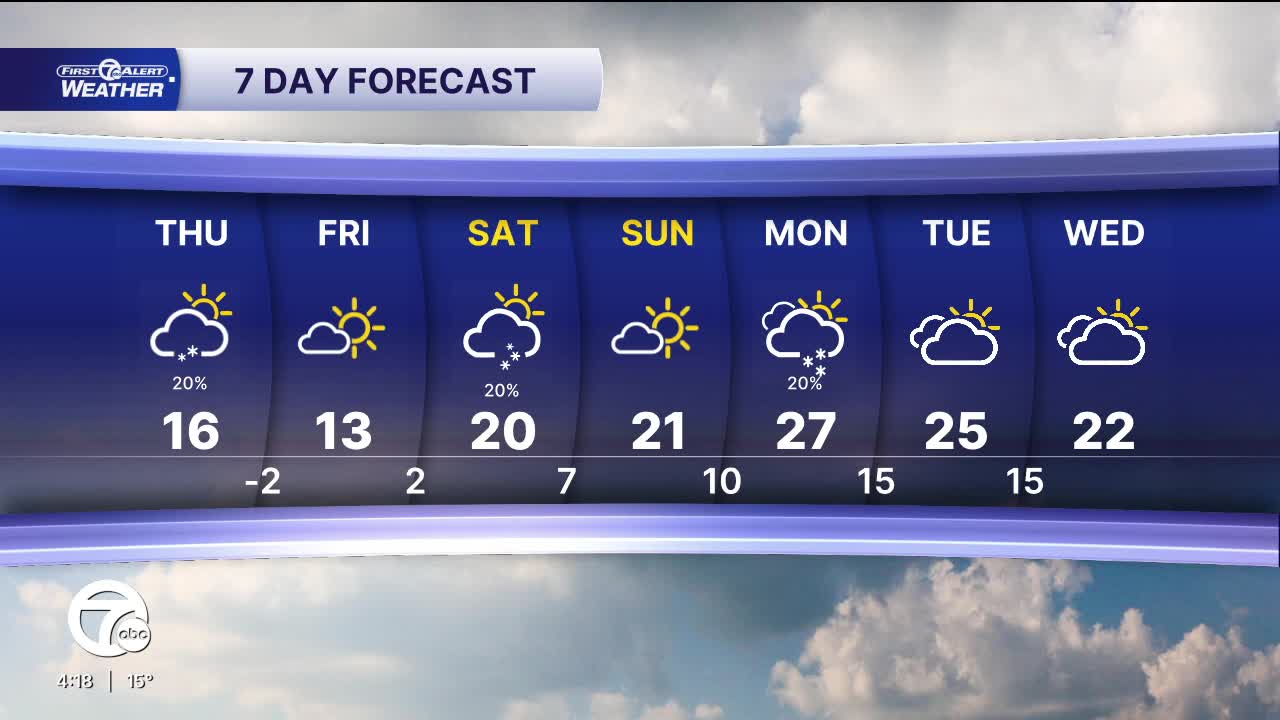
Thursday will be very cold but generally brighter than earlier in the week, with mostly sunny skies and highs only around the mid teens as the arctic air mass remains entrenched over the region. Despite the sunshine, it will still feel bitterly cold, especially in the morning as overnight lows dip below zero again. A snow shower or flurries can’t be completely ruled out, but most of the day will stay dry and crisp with plenty of cold sunshine — making it another brutal winter day where bundling up is essential if you’re outside.
Cold temperatures stick around through the weekend with highs in the mid to upper teens and lows near zero. Wind chills will be -5° to -25° most mornings, with the coldest morning happening Friday.
Tonight: Mostly cloudy with a slight chance for snow. Lows in the single digits with below 0 wind chills. Winds: SW 5-15 G20 mph.
Thursday: Morning starts out cold with wind chills below zero. Mostly sunny with a slight chance for snow. Highs in the mid-teens. Winds: SW 5-15 G20 mph.
Connect with 7 First Alert Meteorologists on Facebook and X:
Facebook: Dave Rexroth , Hally Vogel, Marisa Woloszyn, Mike Taylor
X: Dave Rexroth , Hally Vogel, Marisa Woloszyn, Mike Taylor
Current Conditions
- Humidity: 39%
- Dew point: 59°
- Pressure: 29.96 in
- Wind speed: 11 mph
- Wind direction: NNW
- Visibility: 10.0 mi
- Sunrise: 06:23 AM
- Sunset: 08:54 PM
