

Warmer temps on the way for Wednesday and Thursday, but the wind still has a bite to it tonight with wind chills in the single digits. Strong winds will blow mid week with rain and possibly thunder.
Tuesday, we’re a little warmer, but the cold wind still makes it feel cold. We continue to warm Wednesday with highs pushing 40° and low to mid 40s Thursday.
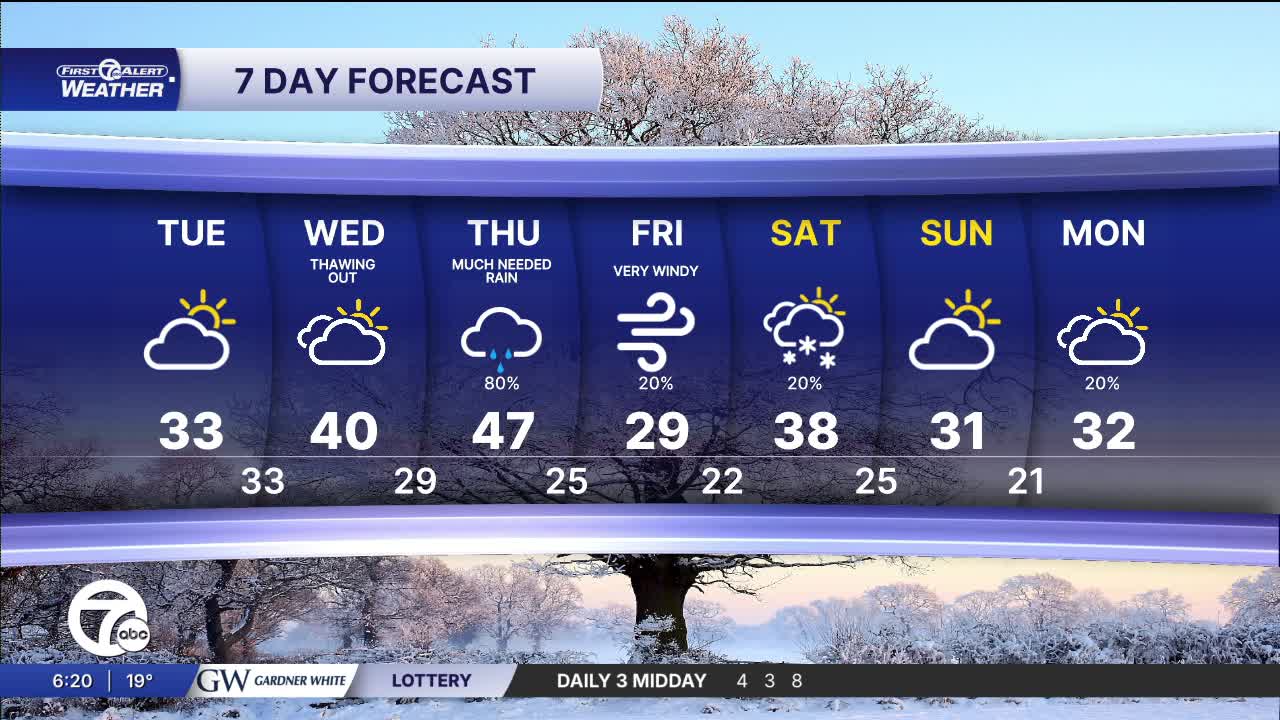
Thursday will be the warmest day of the week with highs in the mid to upper 40s. It's also going to be the rainiest day of the week with widespread rain through most of the day. The rain is along a cold front that will move through late in the day. A little thunder is possible as the front moves through. Behind the front colder air will move in, switching precipitation from rain to snow Thursday night. Light snow will continue into Friday morning with less than 1" of snow expected across the area. High temperatures will be fall back into the upper 20s by Friday afternoon.
See the full forecast in the video below
Looking ahead to Christmas week: it is shaping up to be milder than normal, but also busy, so it’s one we’ll be watching closely. Temperatures look like they’ll spend a lot of time in the 30s and 40s, which means we’re not locked into a deep-freeze pattern. That said, the milder air comes with a more active storm track, bringing periodic chances for rain, and possibly a rain–snow mix if colder air briefly sneaks in behind passing systems. For now, Christmas itself doesn’t scream all-snow or all-warm - but it’s more of a “stay tuned” setup, where timing will matter. Bottom line: not brutally cold, but unsettled, with a few systems to track as we get closer to the holiday.
Tonight: Partly to mostly cloudy skies with lows pretty steady near 16°. Winds: SW 5 mph.
Tuesday: Sun and clouds mixed with a little brighter sun in the afternoon. Highs near 33°. Winds: SW 10-25 mph.
Wednesday: mostly cloudy with highs in the upper 30s to around 40° in Detroit. Winds: WSW 10-20 mph.
Connect with 7 First Alert Meteorologists on Facebook and X:
Facebook: Dave Rexroth , Hally Vogel, Marisa Woloszyn, Mike Taylor
X: Dave Rexroth , Hally Vogel, Marisa Woloszyn, Mike Taylor
Current Conditions
- Humidity: 37%
- Dew point: 58°
- Pressure: 29.95 in
- Wind speed: 9 mph
- Wind direction: NW
- Visibility: 10.0 mi
- Sunrise: 06:23 AM
- Sunset: 08:54 PM
