

A Flood Warning is in effect for the North Branch Clinton Near Mt Clemens, affecting Macomb County. The river is expected to crest. The river will fall below flood stage by Tuesday.
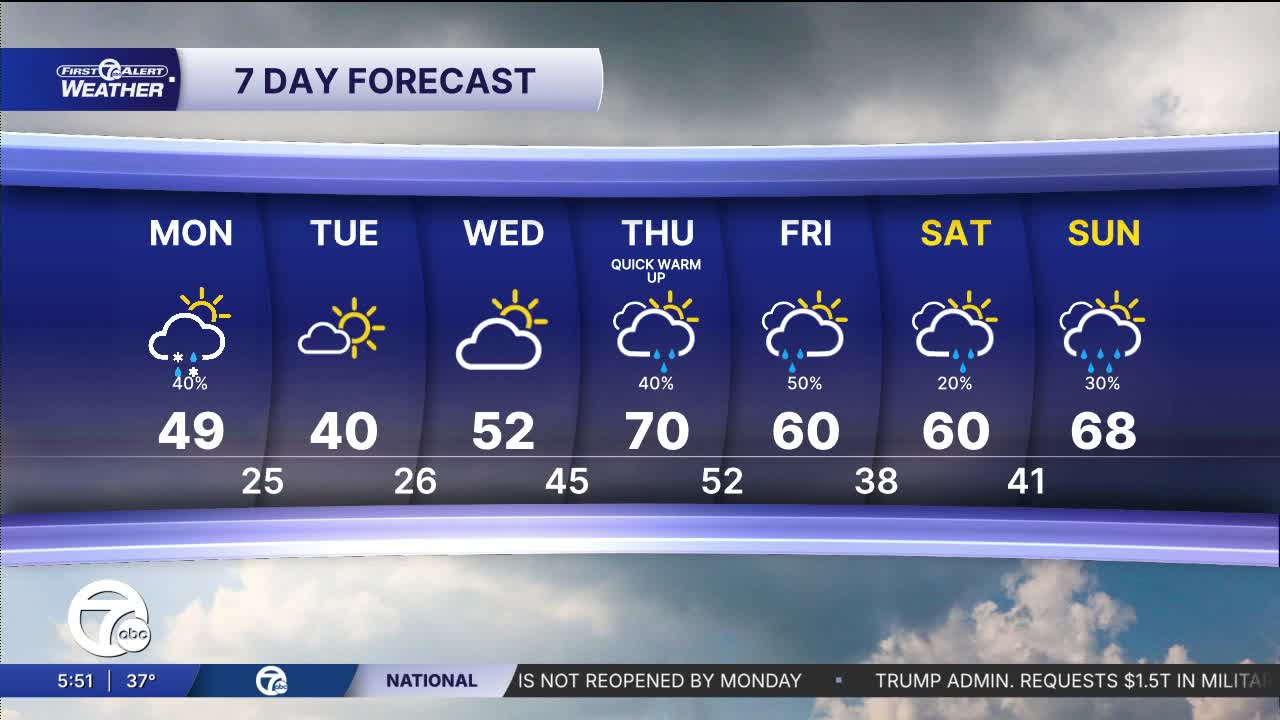
Some light snow and rain showers move in early Monday morning, with a light accumulation possible, mainly on elevated surfaces. Temperatures fall into the low to mid 30s by Monday morning. Rain showers increase around midday through the early evening as temperatures climb into the mid to upper 40s. Winds will be breeze out of the northwest 5-15 mph, with gusts near 25 mph.
See the full forecast in the video below
Tuesday starts chilly with temperatures into the mid 20s and wind chills in the teens. Some flurries are possible. Temperatures will rebound to near 40° with mostly sunny skies.
Warmer air starts to move in Wednesday and temperatures continue to climb through the rest of the week. Wednesday will be partly sunny with highs in the low to mid 50s. Rain showers return Thursday and continue into Friday with highs in the low to mid 60s. More rain showers are expected next weekend.
Tonight: Mostly cloudy. Snow showers late. Lows in the mid to low 30s. Winds: W 5-10 mph.
Monday: Snow and rain showers. Partly sunny. Highs in the mid to upper 40s. Winds: WNW 15 G25 mph.
Connect with 7 First Alert Meteorologists on Facebook and X:
Facebook: Dave Rexroth , Hally Vogel, Marisa Woloszyn, Mike Taylor
X: Dave Rexroth , Hally Vogel, Marisa Woloszyn, Mike Taylor
Current Conditions
- Humidity: 87%
- Dew point: 72°
- Pressure: 29.95 in
- Wind speed: 3 mph
- Wind direction: S
- Visibility: 10.0 mi
- Sunrise: 05:59 AM
- Sunset: 09:14 PM
