


(WXYZ) — A powerful winter storm is hitting metro Detroit for the holidays, disrupting travel plans with high winds, dangerous wind chills and snow.
Check out our live radar below:
Current Conditions
- Humidity: 84%
- Dew point: 61°
- Pressure: 30.07 in
- Wind speed: 1 mph
- Wind direction: N
- Visibility: 2.0 mi
- Sunrise: 06:11 AM
- Sunset: 09:07 PM
CLICK HERE FOR OUR COMPLETE WEATHER COVERAGE
A Winter Weather Advisory is in effect until Saturday evening.
SUNDAY AT 10:00 A.M.
According to DTE Energy's Outage Map, 752 remain without power.

SATURDAY AT 12:40 P.M.
Tweet from MSP's Second District:
Troopers have handled 167 traffic crashes in the district since midnight on the 23rd. The main cause of these crashes have been drivers driving too fast for conditions. So please slow down! #DriveMichiganSafely pic.twitter.com/FRfcTU2960
— MSP Second District (@mspmetrodet) December 24, 2022
SATURDAY AT 12:13 P.M.
According to DTE Energy's Outage Map, 4,751 remain without power.

SATURDAY AT 12:04 P.M.
Tweet from Oakland County Sheriff’s Marine Division:
We received a lot of interest about our rescue of an injured swan on a partially iced over lake. First, no ice is currently safe or predictable. Also, this showed the capability of our rescue team and gives them real world exercise of their rescue skills. Be safe.
— Oakland County Sheriff’s Office (@oaklandsheriff) December 24, 2022
SATURDAY AT 11:02 A.M.
All Eastbound lanes of I-94 at Telegraph in Wayne County are closed due to crash.
SATURDAY AT 10:48 A.M.
Statement from Detroit Metro Airport:
"Happy Christmas Eve! Conditions at the airport began improving—relatively speaking—-yesterday, but we’re still urging customers to check their flight status before heading to DTW. We don’t want anyone driving on the roads and braving the conditions, only to find out their flight is canceled or significantly delayed."
SATURDAY AT 9:58 A.M.
As of 9:58 a.m. Saturday, DTE Energy says 5,161 remain without power.
SATURDAY AT 8:40 A.M.
DTE's Storm Response Team confirms power has been restored for approximately 80% of the 23,300 DTE customers who were impacted by the winter storm. They expect the remainder of customers to have their power restored late Saturday evening.
As of 8:40 a.m. Saturday, 5,120 remain without power.
SATURDAY AT 7:15 A.M.
A winter weather advisory is in effect for Macomb, Oakland, Livingston, St. Clair, Lapeer and Sanilac counties until 7:00 pm.
A wind chill advisory is in effect for Wayne, Washtenaw, Monroe and Lenawee counties until 7:00 pm.
Winds are expected to remain strong today with gusts up to 45 mph possible. This will likely produce strong snow showers coming off of Lake Michigan. The better chances for these snow showers will be between I94 and M59. They will be scattered, but could quickly change visibilities and driving conditions.
FRIDAY AT 11:48 P.M.
7 First Alert Meteorologist Mike Taylor says the weather is looking a little better, but the storm is not over just yet. Winds have started to lose the damaging criteria that could lead to power outages. But the wind is still blowing snow on the roads, keeping them icy and the wind chills low.
Winds from the west and southwest are expected to shift overnight, bringing moisture off the lakes and reigniting the lake effect snow. Wind chills will remain in the sub-zero range overnight.
FRIDAY AT 11:21 P.M.
There were 5,071 DTE customers without power across southeastern Michigan, according to their outage map. Consumers Energy is reporting 6,668 outages across the rest of the state.
The strong winds weren’t enough to cause mass outages Friday. However, the cold was enough to make it miserable for those who did lose power.
FRIDAY AT 8:40 P.M.
Meteorologist Mike Taylor went on Facebook Live to give viewers an online update about what to expect this holiday weekend.
FRIDAY AT 7:45 P.M.
Michigan State Police said as of 7:30 p.m. Friday, the agency has handled about 50 crashes in metro Detroit, adding that none were considered serious.
FRIDAY AT 7:42 P.M.
7 First Alert Meteorologist Mike Taylor provided an update on the winter storm system.
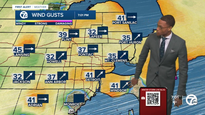
Winds are beginning to relax across metro Detroit, but gusts are still 41 mph in Detroit and 35 mph in Ann Arbor. Wind conditions should continue to improve.
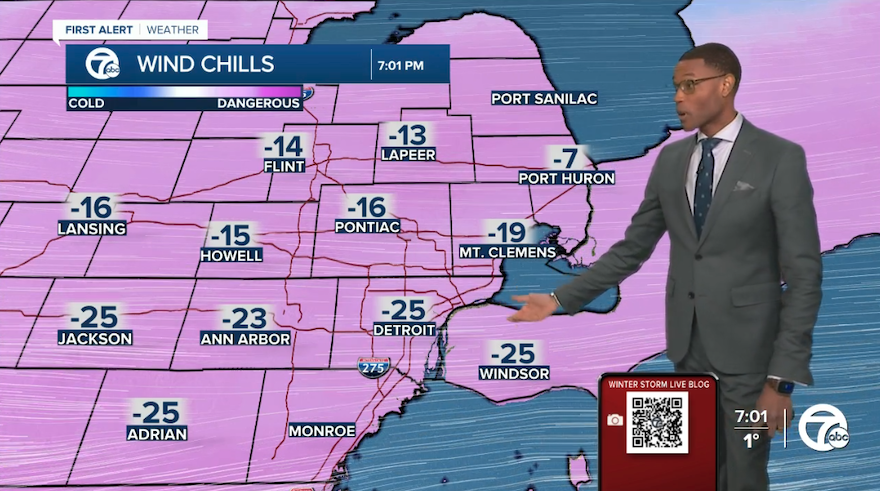
Temperatures remain in the single digits and some snow showers will continue to move through, creating enough for ice on roads. Additional snow squalls are expected to develop in the west and move east, which is why wind chills are in the negative numbers.
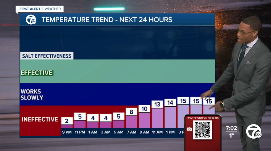
Salt on roads will be pretty much ineffective during the low temperatures tonight. Temperatures are expected to be in the teens Saturday morning, though salt effectiveness will work slowly on roads.
FRIDAY AT 6:11 P.M.
Craig Bryson with the Oakland County Road Commission gave an update on road conditions and treatment during 7 Action News at 5:30 p.m.
He said wind and temperatures have made it challenging to salt roads. They have been focusing on clearing snow as temperatures remain low.
FRIDAY AT 5:51 P.M.
Andrew Kandrevas, director of Wayne County Public Services, joined 7 Action News at 5 p.m. to give an update as crews work to clear roads. He said crews were called in around 10 p.m. Thursday and have been working nonstop. About 120 staff members out working in Wayne County.
Kandrevas had a message for drivers:
"I just have to urge motorists, if you have to be out, please slow down. And if you see a plow, stay as far away from that plow as you can," he said. "You may think it's a safe distance, you may think that plow is just going to have to go its way and I'm going to go my way but really, we are all working hard to keep the roads safe for all of us. Give those plows and give your fellow drivers a wide berth — slow down out there."
FRIDAY AT 4:52 P.M.
The state announced that Gov. Gretchen Whitmer activated the State Emergency Operations Center at 1 p.m. to help respond to dangerous weather conditions. The state says the activation will ensure additional state resources are available for local communities.
No requests have been made from local governments as of 4 p.m., the state said.
“Our top priority right now is keeping Michiganders safe. I am grateful to our first responders, road maintenance crews, utility crews and volunteers at warming centers who are working hard to keep people safe and warm,” Whitmer said in a statement. “By taking this next step to activate the State Emergency Operations Center, we are making sure that our response is coordinated and that resources are available to impacted communities. We will continue to work with local officials and are prepared to offer the full weight of state resources to respond to the storm.”
FRIDAY AT 4:40 P.M.
7 Action News reporter Simon Shaykhet went out on a live drive, giving a look at the challenging road conditions for newscasts at 4 p.m., 5 p.m. and 6 p.m.
REPORTING LIVE: We are checking on icy road conditions across Metro Detroit starting at 4 pm every 30 min. Photographer Matt Dale & I are also making sure you know about areas to avoid & latest information from the Road Commission for Oakland County. #4PM #5PM #6PM @wxyzdetroit pic.twitter.com/BRyprAOTJ9
— Simon Shaykhet WXYZ (@simonshaykhet) December 23, 2022
FRIDAY AT 3:15 P.M.
According to DTE Energy, the number of power outages across southeastern Michigan has increased to 12,228. Consumers Energy is reporting 4,846 across the rest of the state.
FRIDAY AT 1:40 P.M.
As of 1:30 p.m., DTE is reporting an increase in power outages across metro Detroit. They have risen to about 8,260 customers and remain scattered across the WXYZ-TV viewing area.
FRIDAY AT 11:25 A.M.
7 Action News Meteorologist Hally Vogel tracks 49 MPH wind gusts.

"As updates come in, we've created a live blog below on what we know as we prepare for the system. Strong winds and bitterly cold, even dangerously cold, wind chills are the main threat with this storm. Here's a look at peak wind reports and snow reports, so far. Another 1" of so of snow will be possible," said 7 Action News Meteorologist Hally Vogel.

FRIDAY AT 11:15 A.M.
Bronners CHRISTmas Wonderland in Frankenmuth says they will be closed both Friday, December 23rd and Saturday, December 24th due to the weather. The store is always closed and Christmas day and will reopen Monday, December 26th.
FRIDAY AT 10:40 A.M.
Organizers say that because of the weather, many of the events happening around Campus Martius will not be open today. Specifically, The Rink at Campus Martius Park, the Downtown Detroit Markets at Cadillac Square, the Arctic Zone and carriage rides are closed. They currently plan to reopen Saturday.
However, both Parc and Cadillac Lodge are heated and will remain open.
FRIDAY AT 10:02 A.M.
DTE Energy's Outage Map shows 4,613 are currently without power.

FRIDAY AT 9:37 A.M.
Traffic Alert: WB I-96 at Telegraph in Wayne County is closed due to crash. Please avoid the area.

FRIDAY AT 9:08 A.M.
DTE Energy's Outage Map shows 4,207 are currently without power.

FRIDAY AT 9:00 A.M.
Morning ski sessions are canceled at Mt. Holly and Pine Knob due to high winds as winter weather takes over the region. As of 9:05 a.m., Alpine Valley in White Lake is open Friday morning.
FRIDAY AT 8:15 A.M.
The Detroit Institute of Arts announced it will be closed on Friday, December 23 due to winter weather.
"Due to inclement weather conditions and for the safety of our staff and visitors, the DIA is closed today," the DIA said on its website Friday.
FRIDAY AT 8:05 A.M.
USPS, UPS and FedEx announce service disruptions as winter weather impacts U.S.

Click here for the full story.
FRIDAY AT 7:11 A.M.
Local hotels are reporting limited availability as cancellations and delays at Detroit Metro Airport rise as winter weather conditions worsen.

FRIDAY AT 6:40 A.M.
SMART has announced cancellations of some of its routes due to winter weather conditions. For more information about the status of SMART bus routes, click here.

SMART Transit Centers in downtown Detroit and Royal Oak will be closed for the Christmas Holiday Friday through Monday, December 26.
For assistance, contact SMART Customer Care by calling 866-962-5515.
FRIDAY AT 6:00 A.M.
7 Action News meteorologist Hally Vogel tracks the storm as snow begins and wind chills dip below zero.

FRIDAY AT 5:15 A.M.
As wind gusts increase, DTE Energy's Outage Map shows 2,453 are currently without power.
FRIDAY AT 5 A.M.
The transition from rain to snow is complete as much of the metro area is being hit with the show, with moderate bursts of snow in much of Mid Michigan.
As of 5:02 a.m., temperatures are in the teens and wind chills are already below zero for many spots, and wind gusts are approaching 50+ mph in some places.
Watch live coverage of 7 Action News all morning long here.
THURSDAY AT 11:25 P.M.
Rain entered metro Detroit this evening and tonight, snow is inching closer to Washtenaw, Oakland and Livingston counties before going through the entire area. It will continue to get more cold and wet.
Winds are expected to be strong Friday morning and continue throughout the day.
Dangerous travel is expected as temperatures drop from the 30s down to the teens by the Friday morning commute.
THURSDAY AT 8:26 P.M.
7 Action News Chief Meteorologist Dave Rexroth went on Facebook Live to provide an update about the storm with the timing and expected temperatures, wind gusts, snow totals and more.
THURSDAY AT 7:08 P.M.
The Detroit Zoological Society says both Detroit Zoo and the Belle Isle Nature Center will be closed because of the weather on Friday. The closure applies to the Zoo's Wild Lights evening program as well.
They released the following statement:
The Detroit Zoo and Belle Isle Nature Center will temporarily close on Friday, Dec. 23 due to the threat of a major winter storm expected to impact the metro Detroit region. This closure includes both normal daytime operating hours at the Zoo and Nature Center, as well as scheduled Wild Lights events in the evening at the Detroit Zoo.
The safety of our guests and the animals who call the Detroit Zoo and Belle Isle Nature Center home is our top priority. Essential workers, such as animal care staff, will still be present on our campuses to provide animals the proper, ongoing care they need.
Guests who purchased a ticket to visit the Zoo during normal operating hours will have their ticket honored for admission into the Zoo on any date through Tuesday, Jan. 31, 2023. For guests who purchased admission to Wild Lights at the Zoo, tickets will be automatically validated for any of the upcoming Wild Lights dates with no additional cost. Please visit wildlights.detroitzoo.org for dates and times of future Wild Lights events. Refunds will not be issued if guests choose to attend Wild Lights or decide not to visit on a later date.
The Belle Isle Nature Center in Detroit will not be open to the public even if entrance to Belle Isle State Park is permitted.
Our leadership team at the Detroit Zoological Society will continue to monitor the latest weather forecasts to determine when the Detroit Zoo and Belle Isle Nature Center can safely reopen.
For the latest, most up-to-date news on reopening information, please visit the Belle Isle Nature Center and Detroit Zoo Facebook pages.
THURSDAY AT 6:57 P.M.
7 Action News Chief Meteorologist Dave Rexroth has updated his forecast for the storm, with the details highlighted in the following pictures.
The picture below shows the timeline, as well as the updated details.
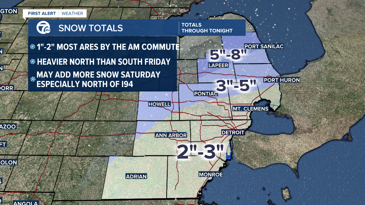
The image below shows the updated projected snow totals.
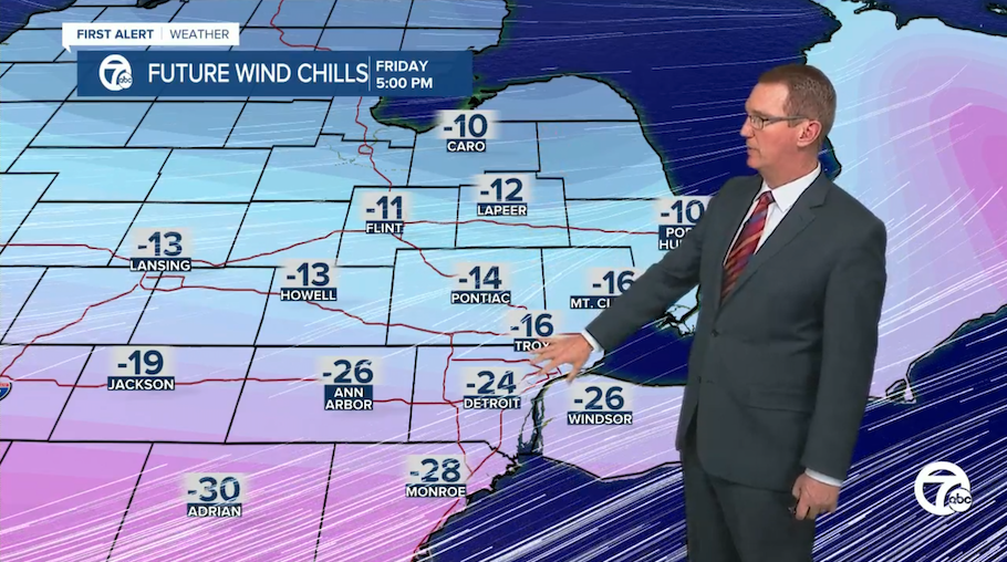
The photo below shows the updated projected wind chills.

The photo below shows the updated projected wind gusts.

The image below shows Dave's updated projection for travel conditions throughout the storm.

THURSDAY AT 6:38 P.M.
Additional organizations have announced warming centers being open for the homeless and vulnerable population and are also offering overflow.
Outreach groups like Homeless Action Network of Detroit and Cass Community Social Services are offering space for those in need. Costick Activities Center in Farmington Hills is also a warming center.
Anyone who needs someone to go during the frigid temperatures can call 313-305-0311.
THURSDAY AT 6 P.M.
Hundreds of families packed the Detroit Metropolitan Wayne County Airport. As of Thursday afternoon, more than 60 flights were delayed or canceled at DTW. The latest flight delay information can be found on their website.
THURSDAY AT 4 P.M.
One of the biggest dangers of the subzero weather is frostbite. Our Chief Health Editor Dr. Partha Nandi gives us some advice on how to stay safe during this extremely cold weather.
Here are some tips to prevent frostbite:
- Bundle up! Wear thick socks, a hat, scarf and gloves to prevent exposed skin.
- Dress in layers to help trap warm air against your body.
- Stay hydrated, eat regular meals and stay active to keep your blood flowing .
- Don't drink alcohol
- Stay dry. Remove any wet clothing as soon as possible.
- Limit your time outside.
THURSDAY AT 3:16 P.M.
The Henry Ford has announced that all operations will be closed Friday. They made the announcement in a Facebook post:
THURSDAY AT 2:51 P.M.
Flights to and from cities already being hit by the winter storm like Chicago and St. Louis are being impacted at Detroit Metro Airport.
Check your flight status or learn how to contact your airline here: https://www.wxyz.com/news/flights-to-and-from-metro-airport-feeling-winter-storms-effects
THURSDAY AT 1:51 P.M.
Several communities have already declared Snow Emergencies ahead of the storm's impact.
For the full list, click here.
THURSDAY AT 1:29 P.M.
Many metro Detroit schools are already announcing closures as the winter storm heads towards southeast Michigan.
For the full list of school closures, click here.
THURSDAY AT 12:20 P.M.
An updated forecast by Meteorologist Hally Vogel.
THURSDAY AT 10:20 A.M.
Macomb County Roads Department and Emergency Management are holding a storm meeting at 11a.m. to test its 200 road cameras. The road cameras give Michigan drivers the chance to see traffic in real time.
THURSDAY AT 7:30 A.M.
The Village of Pinckney is declaring a snow emergency effective Thursday at 5 p.m. through Saturday at 12 p.m..
Drivers must move their cars off the streets to allow for the safe removal of snow, ice and debris from the roadway.
THURSDAY AT 6:45 A.M.
A message from DTE: "Today is the day to start [making] sure you have batteries operating. Flashlights, fire wood if you have a fire place, and insulated windows. But we will have much more on how to prepare for a winter storm tomorrow morning."
THURSDAY AT 5:15 A.M.
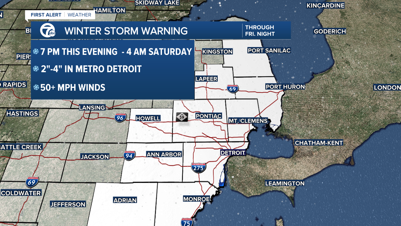
A winter storm warning for southeast Michigan begins at 7 p.m. this evening and runs until Saturday morning at 4 am. The main threat is winds up to 50 mph, extreme cold, and snow of 3"-6".
The heavier amounts will be north and west of Detroit.
WEDNESDAY AT 6:17 P.M.
Gov. Gretchen Whitmer released a statement Wednesday evening saying first responders, road maintenance crews, utility companies and warming centers are prepared for the winter storm.
“With potentially dangerous winter weather on the way, it is important to prepare and be ready ahead of time to keep yourself, your family, and your neighbors safe,” Whitmer said. “The State of Michigan is closely watching conditions as they develop and taking action to prepare for winter weather impacts. We will continue working hard to protect the health and safety of Michiganders, and are grateful for the dedicated first responders working to keep Michiganders safe this weekend.”
You can find warming centers near you by visiting mi211.org and searching "warming centers." You can also call 211.
WEDNESDAY AT 4:38 P.M.
Meteorologist Dave Rexroth has a look at predicted snow totals across the metro Detroit area.
Check out the map below:
Snow totals from late Thursday night through Friday night. We certainly could add more with the Saturday snow showers. With the high winds some areas will look bare and others will have significant drifts. pic.twitter.com/ycWw7PPJ6H
— Dave Rexroth (@rexroth7wxyz) December 21, 2022
WEDNESDAY AT 4 P.M.
DTE Energy provided an update around 4 p.m. to let the public know their plans ahead of the storm. DTE Electric President Trevor Lauer says crews are prepared to handle power outages and downed wires with more than 700 line workers.
Lauer said strong winds could cause delays due to safety reasons for workers. He says crews can work in wind conditions of about 30 mph, but cannot much higher than that. He added that, "We will come and we will restore the outages."
He emphasized two important safety tips for customers:
- Don't bring a generator inside your home as that can cause carbon monoxide poisoning
- If you see yellow tape and wires down, stay away. Call DTE for wires that haven't been reported.
WEDNESDAY AT 3 P.M.
A Winter Storm Warning has been issued for southeastern Michigan starting Thursday evening through Saturday early morning.
WEDNESDAY AT 2:50 P.M.
DTE Energy announced they will be holding a press conference on storm preparedness and planning this afternoon.
You can watch the press conference in this blog at 4 p.m.
WEDNESDAY AT 2:30 P.M.
Good info to have on hand, thanks to the Michigan Public Service Commission:
If your power goes out in the storm barreling toward Michigan, here's how to contact your utility. Be prepared. pic.twitter.com/Yy67SXAsKU
— MI Public Service Commission (@MichiganPSC) December 21, 2022
WEDNESDAY 2:40 P.M.
Consumers Energy said in a statement that they are preparing for the large winter storm expected to hit the area.
“Consumers Energy customers should know we are all-hands-on-deck preparing for this storm. Crews are preparing trucks and essential materials right now to assist with any restoration efforts,” said Garrick Rochow, President and CEO of Consumers Energy, in a statement. “We are ready and we’ll work as quickly and as safely as possible to restore any outages this storm may cause. We are grateful for our customers’ patience and understanding.”
They recommend Michiganders get ready for the storm, offering the following tips:
· Charge all electronic devices. It’s advised to have an emergency battery or charging station available for use during an outage.
· Have an emergency kit that includes flashlights and extra batteries, water, canned food and blankets. Be prepared with enough medication, baby supplies and pet food if applicable. A battery-operated radio is also a good idea.
· Unplug sensitive electronics like TVs, computers and printers. Turn power strips off.
· Stay at least 25 feet away from downed wires and anything they are touching, keep children or pets away, and report the issue by calling 9-1-1 and Consumers Energy at 800-477-5050.
· A portable generator should be placed at least 25 feet away from any doors, windows or fresh air intakes. Never operate a generator inside your home, garage, basement or enclosed area. Proper ventilation is critical.
· Be alert to crews working along slick roads. Drivers should slow down or stop and wait for oncoming traffic to clear so they safely can go past workers on roadsides.
WEDNESDAY 2:11 P.M.
Meteorologist Dave Rexroth provided a quick update this afternoon and said the storm that moves in Thursday night through Saturday will be more impactful than most winter storms because of the wind, cold, and blowing and drifting snow that's expected to cause dangerous travel.
A breakdown of some of the concerns related to this storm:
- Weather causing dangerous travel situations Friday through Saturday with the possibility of near zero visibility at times
- High winds that could cause widespread power outages
- Cold temperatures and wind chills below zero for days, which could make any power outages dangerous
- Incoming snowfall
When the rain changes to snow Thursday overnight, it will happen very fast. We're anticipating that freezing rain will not be very likely because of how fast the change will happen. Expect icy conditions from wet roads as the temps drop.
Most of the snow will be light and will blow and drift significantly since temps will drop through the 20s quickly early Friday morning. The snow will be widespread Friday and Friday night and then be more scattered Saturday.
The snow Saturday in bands from Lake Michigan could be locally very heavy at times.
WEDNESDAY 1:12 P.M.
Detroit officials held a press conference on Wednesday afternoon to go over preparations underway ahead of the holiday winter storm.
Officials say as soon as the rain turns to snow overnight Thursday into early Friday morning, crews will be ready to go out and salt. They have about 50 trucks working around the clock on the major roads until the snow stops and the streets are cleared. Depending on how much snow we get, officials will make a call on whether to bring in additional contractors.
Since high winds are expected, officials are urging people who don't need to be out on Friday to stay home.
Watch the full press conference below:
WEDNESDAY 1:02 P.M.
The City of Westland has opened several warming centers that will be available 24/7 for residents who are in need of a place to stay warm and charge devices.
- The Westland Police Department lobby, 36701 Ford Road
- All of the Fire Stations:
- Ralph Savini Fire Station 1, 35701 Central City Parkway
- Fire Station 2, 7825 Merriman Rd.
- Fire Station 3, 28801 Annapolis
- Fire Station 4, 37200 Palmer
If you see someone who is out in the cold, call 911 or the non-emergency police line at 734-722-9600.
WEDNESDAY 12:50 P.M.
Meteorologist Hally Vogel is saying we have a longer duration storm we're dealing with here.
Expect rain tomorrow turning over to snow, and an icy mess by Friday morning with temps plummeting.
The wind is really the talker. Hally says to anticipate Friday and Saturday "wind whipped snow."
As far as the amount of snow, expect about 4 inches to 6 inches with more to the north and west.
Check out her latest forecast below:
WEDNESDAY 12:17 P.M.
City of Detroit officials plan to hold an afternoon news conference on preps underway for the winter storm. The press conference is expected to happen at 1 p.m.
WEDNESDAY 10:21 A.M.
Three warming centers that offer meals, showers, sleeping accommodations and housing assistance services are open in Detroit to help those experiencing homelessness.
If you are looking for a placement, you can call 313-305-0311 from 9 a.m.-6 p.m. Mondays, Tuesdays, Thursdays, and Fridays and 11 a.m.-5 p.m. Wednesdays for help.
Veterans looking for shelter can go to the Dingell VA Hospital, 4646 John R St., Red Tower 2nd Floor, from 8 a.m.-4:30 p.m. Mondays, Tuesdays, Thursdays, and Fridays or 11 a.m.-4:30 p.m. Wednesdays.
Those looking for shelter can go to the following locations:
- Cass Community Social Services
Address: 11850 Woodrow Wilson St., Detroit 48206
Phone number: (313)883-2277
Facility open for: Families and single women
- Detroit Rescue Mission Ministries - Mack Warming Center
Address: 11037 Mack Ave., Detroit, MI 48214
Phone number: (313)331-8990
Facility open for: Families and single women
- Detroit Rescue Mission Ministries - Third Street Warming Center
Address: 3535 Third Ave., Detroit, MI 48201
Phone number: (313)993-6703
Facility open for: Single men
For more information on shelters and warming centers, call 313-305-0311.
There are also locations where people can go to get warm during the day. The libraries are doing a limited capacity and requiring masks:
- Bowen Branch3648 W. Vernor/W. Grand Blvd., Detroit, MI 48216 • (313)481-1540 Hours: M, W & Sa: 10 a.m. - 6 p.m.; T & Th: Noon - 8 p.m.
- Campbell Branch8733 W. Vernor/Springwells, Detroit, MI 48209 • (313)481-1550 Hours: T, Th, & Sa: 10 a.m. - 6 p.m.; M & W: Noon - 8 p.m.
- Chandler Park Branch12800 Harper, Detroit, MI 48213 • (313)481-1560 Hours: W & Sa: 10 a.m. - 6 p.m.; Th: Noon- 8 p.m.
- Duffield Branch2507 W. Grand Blvd./14th St., Detroit, MI 48208 • (313)481-1710 Hours: M, W & Sa: 10 a.m. - 6 p.m.; T & Th: Noon - 8 p.m.
- Edison Branch18400 Joy/Southfield, Detroit, MI 48228 • (313)481-1720 Hours: T, Th & Sa: 10 a.m. - 6 p.m.; M & W: Noon - 8 p.m.
- Elmwood Park Branch550 Chene/Lafayette, Detroit, MI 48207 • (313)481-1730 Hours: M, W, Sa: 10 a.m. - 6 p.m.; T & Th: Noon - 8 p.m.
- Franklin Branch13651 E. McNichols/Gratiot, Detroit, MI • (313)481-1740 Hours: M, W, Sa: 10 a.m. - 6 p.m.; T & Th: Noon - 8 p.m.
- Knapp Branch13330 Conant/E. Davison, Detroit, MI 48212 • (313)481-1770 Hours: T, Th & Sa: 10 a.m. - 6 p.m.; M & W: Noon - 8 p.m.
- Main Library5201 Woodward Ave., Detroit, MI 48202 • (313)481-1300 Hours: T & W: Noon - 8 p.m.; Th, F & Sa: 10 a.m. - 6 p.m. Su (Oct-May): 1 - 5 p.m.
- Parkman Branch1766 Oakman Blvd./Linwood, Detroit, MI 48238 • (313)481-1810 Technology, Literacy & Career (TLC) Center: (313)481-1814 Hours: T, Th & Sa: 10 a.m. - 6 p.m.; M & W: Noon - 8 p.m.
- Redford Branch21200 Grand River/W. McNichols, Detroit, MI 48219 • (313)481-1820 Hours: T, Th & Sa: 10 a.m. - 6 p.m.; M & W: Noon - 8 p.m.
- Sherwood Forest Branch 7117 W. 7 Mile Rd./Livernois, Detroit, 48221 • (313)481-1840 Hours: M, W & Sa: 10 a.m. - 6 p.m.; T & Th: Noon - 8 p.m.
- Wilder Branch7140 E. 7 Mile Rd./Van Dyke, Detroit, 48234 • (313)481-1870 Hours: M & W: Noon - 8:00 p.m.; T, Th & Sa: 10 a.m. - 6 p.m.
WEDNESDAY 9:27 A.M.
The Michigan Humane Society is reminding people to keep pets safe indoors during the storm.
Here are their recommendations on how to keep your furry friends healthy:
- Bring pets indoors to a climate-controlled space
- Limit time outdoors to bathroom breaks and provide sweaters or coats, removing them once back indoors
- Make sure they have access to clean water that is not frozen
- If you are using a dog house, make sure it meets standards set by the state of Michigan for appropriate shelter
If you do see an animal that's been left outside without proper food, water or shelter, you can call Michigan Humane at 313-872-3401 in Detroit, Hamtramck or Highland Park. If outside those areas, call your local animal control or police department.
WEDNESDAY 9:24 A.M.
Michigan State Police is advising Michiganders to prepare for the upcoming severe weather. They advise having a supply of items at home, at work, and in family vehicles ready in advance for use during a power outage or if you get stranded.
Here's what they recommend:
- Develop a 72-hour emergency supply kit that includes essential items like a three-day supply of food and water, a battery-powered or hand-crank weather radio, blankets, flashlights with extra batteries and emergency contact information.
- Know the difference: a Winter Storm Watch means a winter storm is possible in your area; a Winter Storm Warning means a winter storm is occurring or will soon occur in your area.
- Identify a safe alternative heat source and supply of fuel in the event of a power outage.
- Listen to the radio and TV for weather reports and emergency information.
- Stay inside during winter storms. If you must go outside, wear several layers of lightweight clothing, a hat and gloves to prevent loss of body heat. Cover your mouth to protect your lungs.
- For those requiring oxygen, ensure you have a backup power source in case of long-term power outages.
Here's what they recommend when it comes to your vehicle:
- Carry an emergency supply kit in your vehicle with essential items such as salt, sand, a shovel, food and blankets.
- Ensure your car has the proper mix of antifreeze and water in the cooling system and that windshield washing fluid is topped off.
- Keep tires at the car manufacturer’s recommended pressure and routinely check tire pressure during cold weather.
- Keep the fuel tank near full to prevent freezing of the fuel line.
- When traveling, let someone know your destination, route and expected arrival time
WEDNESDAY 9:10 A.M.
A Winter Storm Watch was issued overnight for Southeastern Michigan starting Thursday evening through Saturday evening.
Here's what we know about the storm timeline:
Thursday brings a chance of a mix of snow and rain through midday. Then it will likely rain through 3 a.m. to 4 a.m.
On Friday, expect widespread travel disruptions.
We anticipate there will be a quick drop in temps from the 30s to the teens, making the rain turn to snow between 4 a.m. and 6 a.m. Roads could quickly become icy, especially after 6 a.m.
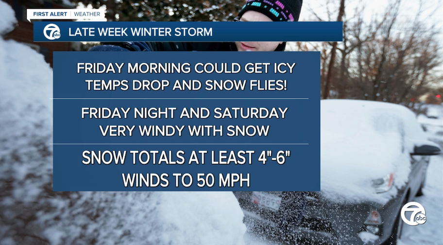
The snowfall that's expected to move in Friday throughout the day and night will have the heaviest amounts toward the west and north of Detroit. We're predicting about 4 inches to 6 inches widespread. It will be enough to shovel, but it's not the primary issue with this storm.

Friday evening, temperatures are expected to drop in the 7- to 12- degree range with blowing and drifting snow, meaning roads will stay snow covered and slippery.
The bigger story: the winds!
There's a high likelihood of high winds reaching 50+ mph across the Great Lakes region. This could lead to power outages, which is always a bad situation in the winter. These winds may also lead to the storm reaching blizzard levels. When we hear the word "blizzard," we may picture a lot of snow, but the term refers to gusty winds and low visibilities while snow is falling as opposed to the amount of snow.
SATURDAY AND BEYOND
The winds appear to stay strong all the way through Saturday, according to models.

Arctic air will follow closely behind this storm with sub-zero wind chills and actual temps in the teens and single digits. This will set us up for the coldest Christmas in over 20 years, possibly longer.


Stay with the 7 Action News team throughout the week as we track this developing storm closely.
